| Above: A surge of dust from the coast of Africa advances towards the United States, as seen on June 26, 2018. Image credit: NOAA/RAMMB. |
An unusually concentrated plume of African dust invaded the U.S. over the weekend, bringing dangerously high levels of fine particulate pollution (PM2.5, particles less than 2.5 microns or 0.0001 inch in diameter). The dust from the Saharan Air Layer (SAL) arrived in Texas on Thursday, and spread northwards and northeastward into the Tennessee Valley over the weekend. The high levels of African dust in combination with human-generated pollution brought the highest PM2.5 levels of the year to 24 of the 37 monitoring locations in Texas over the weekend.
Update: We reported early Monday afternoon that according to on-line data available from the Texas Commission on Environmental Quality, monitors in Dallas/Ft. Worth and Houston on Saturday and Sunday measured the highest 24-hour PM2.5 levels recorded in those cities since at least 1998 (a red or "Unhealthy" Air Quality Index). However, these numbers have been revised, and the two monitors in question now show PM2.5 levels in the "Moderate" range.
 |
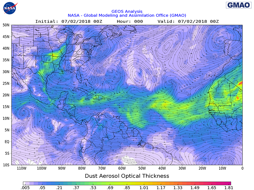
| Figure 1. A plume of Saharan dust extended from the coast of Africa into the Caribbean, then northwards into Texas, Oklahoma, Missouri, Illinois, and surrounding states, as analyzed by the 8 pm EDT Sunday July 1, 2018, run of NASA’s GMAO model. The dust outbreak was one of the ten most intense of the past fifteen years. |
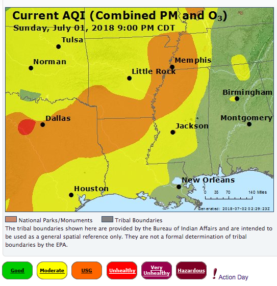
Two of six monitoring stations in the Dallas/Ft. Worth area violated the 24-hour PM2.5 standard of 35 μg/m3 over the weekend, as did one of five stations in the San Antonio region and both stations in the Tyler-Longview-Marshall area. These violations were for an AQI in the “Unhealthy For Sensitive Groups” (orange) range. The dust also led to a rare PM2.5 violation in Arkansas on Sunday, at the El Dorado monitor. According to statistics from the American Lung Association, Arkansas did not experience any PM2.5 violations between 2014 and 2016. (Note that it's referred to as a "violation" when PM2.5 levels exceed the EPA guidelines even if the cause is partially natural, such as from Saharan dust.)
 |
| Figure 2. Observed air quality index (AQI) for 9 pm CDT Sunday, July 1, 2018. A plume of African dust extended from Texas into the Tennessee Valley, causing high levels of PM2.5 pollution. Regions colored in orange saw PM2.5 levels in excess of the federal standard, reaching the “Unhealthy For Sensitive Groups” range. A region near Ft. Worth experienced an AQI in the “Unhealthy” (red) range. Image credit: U.S. EPA. |
A very dangerous air pollution episode
A PM2.5 episode as widespread and severe as this is a threat to cause hundreds of premature deaths. According to a 2018 study done by the Health Effects Institute (a U.S. non-profit corporation funded by the EPA and the auto industry), PM2.5 pollution in the U.S. caused approximately 87,000 premature deaths per year between 2010 and 2016. Air pollution deaths are calculated using epidemiological studies, which correlate death rates with air pollution levels. Air pollution has been proven to increase the incidence of death due to stroke, heart attack and lung disease. Since these causes of death are also due to other factors—such as lifestyle and family history—we typically refer to air pollution deaths as premature deaths. A premature air pollution-related death typically occurs about twelve years earlier than it otherwise might have, according to Caiazzo et al., 2013.
On Friday, a new study linked PM2.5--even at levels deemed safe--to increased incidence of diabetes. The researchers estimated that pollution contributed to 3.2 million new diabetes cases globally in 2016—about 14% of all new diabetes cases globally that year. The study found an increase in diabetes occurred for annual-average PM2.5 levels of 2.4 micrograms per cubic meter--well below the EPA annual standard of 12 micrograms per cubic meter.
Comparison of air quality over Houston taken seven weeks apart. From the Greenway Plaza area.
— Billy Forney 3 (@BillyForney3) June 29, 2018
Saharan dust has definitely arrived.#houwx pic.twitter.com/LuGvxFzyGV
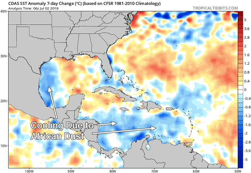
The PM2.5 air pollution episode is likely to continue for Texas and the Tennessee Valley through Tuesday, according to forecasts from NASA’s GMAO model, which shows the dust pushing northeastward and slowly diluting over the next few days. PM2.5 levels were once again in the “Unhealthy” (red) zone for Ft. Worth, Texas on Monday afternoon, and in the “Unhealthy For Sensitive Groups” (orange) range on the east side of Houston. One positive effect of the dust: it blocked enough sunlight to cool SSTs by up to a degree Centigrade, relative to average, over the Caribbean and western Gulf of Mexico during the past week. This will provide less heat to fuel potential hurricanes that might form during the coming hurricane season (more on this in our next post, on Tuesday).
 |
| Figure 3. Change in sea surface temperatures (SSTs) for the 7-day period ending at 2 am EDT July 2, 2018. A large cloud of African dust blocked enough sunlight to cool SSTs by up to a degree Centigrade, relative to average, over the Caribbean and western Gulf of Mexico during the past week. Image credit: Levi Cowan, tropicaltidbits.com. |
Dangerous ozone pollution event continues for Northeast U.S.
The heat wave that began late last week brought the worst ozone air pollution thus far this year to much of the Midwest and Northeast United States. An Ozone Action Day was declared for 24 U.S. cities for Friday, 60 cities on Saturday and Sunday, and 72 cities on Monday. Seven out of ten ozone pollution monitoring sites in the New York City area recorded 8-hour average ozone levels in excess of the federal standard of 70 ppb over the weekend. The highest levels of 82 ppb were measured on Sunday at the City College of New York; this was the site’s fourth ozone violation of the year. Three of Connecticut’s twelve monitoring sites also had ozone levels in violation of the federal standard over the weekend. New Jersey had ozone violations at six stations on Saturday, and four stations on Sunday. Two of the Sunday violations were for an ozone AQI in the red or "Unhealthy" range.
Ground-level ozone, which has been blamed for approximately 12,000 premature deaths per year in the U.S. between 2010 and 2016, is created from chemical reactions between volatile organic compounds (VOCs) and nitrogen oxides in the presence of sunlight. The chemical reactions that create ozone happen faster at high temperatures, and the current heat wave can be expected to cause one of the most dangerous ozone pollution events of 2018. Pollution levels are expected to be higher on Monday over much of the Northeast U.S., due to the extra pollution that weekday traffic and business activity puts into the air. The EPA expects all the major cities of Northeast U.S. will top out in the “Unhealthy For Sensitive Groups” (orange) range for ozone on Monday, with portions of Southeast New York and southwest Connecticut reaching the “Unhealthy” (red) range. At this level of pollution, people who are sensitive to air pollution are at increased risk of stroke, heart attack and breathing problems, and even healthy people may experience discomfort. By early Monday afternoon, portions of New Jersey and New York were already seeing an ozone AQI in the red "Unhealthy" range. On an Ozone Action Day, you are encouraged to:
- Conserve electricity and set your air conditioner at a higher temperature.
- Choose a cleaner commute—share a ride to work or use public transportation. Bicycle or walk to errands when possible.
- Refuel cars and trucks after dusk.
- Combine errands and reduce trips.
- Limit engine idling.
- Use household, workshop, and garden chemicals in ways that keep evaporation to a minimum, or try to delay using them.
San Francisco sky is bizarre right now. Rayleigh scattering through this cloud is depleting all the blues and leaving us with a sepia sky. pic.twitter.com/weUDCkulsN
— Rick Zuzow (@RickZuzow) July 1, 2018
San Francisco sky is bizarre right now. Rayleigh scattering through this cloud is depleting all the blues and leaving us with a sepia sky. pic.twitter.com/weUDCkulsN
— Rick Zuzow (@RickZuzow) July 1, 2018California fire contributes to poor air quality
A fire that began on Saturday northwest of Sacramento, California has spread haze and poor air quality as far south as San Francisco. The fast-moving fire, fanned by high winds, had burned over 50 square miles in Yolo County and was 2% contained by Sunday night. A dusting of ash fell as far away as San Francisco, where tourists snapped pictures of the Golden Gate Bridge enveloped in an orange shroud of fog and smoke.
 |
| Figure 4. Eduardo Velev cools off in the spray of a fire hydrant on Sunday, July 1, 2018, in Philadelphia, Pennsylvania. Temperatures hit 95°F on both Saturday and Sunday in Philadelphia, with nighttime lows well above 70°F, and Monday and Tuesday could be even hotter. Image credit: Photo by Jessica Kourkounis/Getty Images. |
Heat wave slogs into U.S. holiday week
Torrid temperatures and hellacious humidity plagued much of the eastern United States and Canada over the weekend. For most folks, relief will be minimal until later this week, when the heat dome is predicted to shift toward western North America.
The past weekend didn’t bring a swarm of record highs so much as a widespread swath of very uncomfortable air, the kind that becomes a bigger threat for heat-related illness the longer it persists. The National Weather Service heat index—the “feels like” temperature, taking into account air temperature and moisture—pushed well above 100°F from the Midwest to the Northeast, including 107°F at Grand Rapids, MI, on Saturday and 109°F at Albany, NY on Sunday. The most extreme conditions by local standards were in parts of New York, New England, and southeast Canada, where dew points (a measure of the absolute amount of moisture in the air) were about as high as they ever get in some locations. Heat advisories remained in effect east of the Appalachians from Virginia to Maine on Monday.
At Burlington, Vermont, the Monday-morning low was an incredible 81°F. If this low holds till midnight, it will be the warmest daily low ever recorded in Burlington, topping the 78°F recorded on several occasions since records began there in 1884. An NWS forecaster in Burlington put it this way at 3:34 AM on Monday morning, when temperatures were hovering around 85°F with a 73°F dewpoint: “The south wind around 10 mph feels like a misplaced trade wind from the tropics.” Downstream, it’s possible that Caribou, Maine, will challenge its all-time warmest daily low (71°F) on Tuesday.
Just north of the border, Montreal celebrated Canada Day on July 1 with a record-setting high for the date of 33.9°C (93°F), topping the old record of 33.2°C from 1963. Sunday night saw nature putting on a fireworks show of its own in the Montreal area, as more than 15,000 lightning strikes were recorded within 50 kilometers of the city.
Bob Henson wrote the heat wave portion of this post.


