• General
• General
Blame my Christmas/New Year break... I have been suffering from writer’s block this week.
- What measurement or business case can I highlight? … Nothing.
- News that sparks a thought idea for the Insider newsletter? … Nothing.
So, I decided to go back to the start — What swayed me from being a Satelytics customer to a Satelytics team member?
Of course, Satelytics is absolutely a company offering disruptive technology and service, both of which make me proud, but the answer for me is simpler … QUANTIFICATION.
Satelytics’ scientists and software professionals build tools that quantify constituents on land, water, or in the air . . . From the edge of space. Is it a gray pine or an oak tree, and how tall is it?
What is the surface temperature on land or water? What is the concentration of phosphorus? How much has that piece of land moved over the past 4 months? What is the pH near that process outlet?
How can our algorithms do that? The answer goes back to the people behind the scenes. Our algorithm developers are experts in the field of remote sensing and spectral science. They are the people gathering samples in the field, then going back to the office to analyze the data and build passive response models with geospatial data sets for the customer’s constituents of interest. For these customers, detection isn’t enough — it must be quantification as well.
And what is the accuracy? Our science team doesn’t release a new measurement tool unless it is within 10%, and with machine learning, the algorithms become increasingly accurate. More on that next.
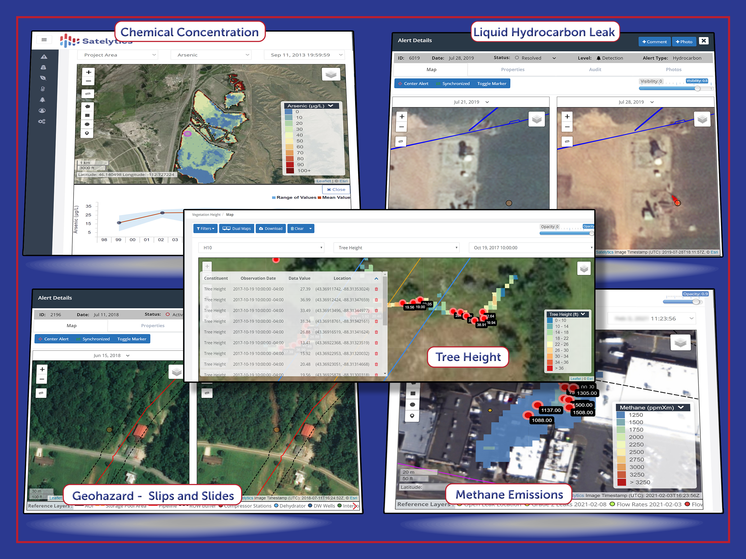
Examples of Satelytics' quantifying algorithms.
Our algorithms analyze the infrared wavelengths of satellite imagery. Once a spectral algorithm is built, our artificial intelligence professionals go to work building models that ingest very large datasets, often terabytes for singular projects. With machine learning, the already excellent accuracy gets better with every pixel of data that is reviewed. Today, our phosphorous or metals measurements are accurate within a few parts per billion. A methane analysis conducted for a large utility customer this summer correctly identified 98.5% of leaks over the target area and flowrate accuracy was within 6% of the ground measured value. The Satelytics team builds measurements that yield actionable alerts within a few hours of the satellite overpass.
For me it always comes back to quantification — detection just isn’t enough.
Take a leap ahead in your monitoring and risk management programs with Satelytics.
We use cookies to analyze our web traffic and to enhance your experience. By continuing to view this website, you agree to our use of cookies.
Our Privacy Policy