Scour Evolution Downstream of Submerged Weirs in Clear Water Scour Conditions


1
Key Laboratory of Coastal Disaster and Defense (Hohai University), Ministry of Education, Nanjing 210024, China
2
College of Harbour, Coastal and Offshore Engineering, Hohai University, Nanjing 210024, China
3
School of Civil and Environmental Engineering, Nanyang Technological University, Singapore 639798, Singapore
*
Author to whom correspondence should be addressed.
Water 2019, 11(9), 1746; https://doi.org/10.3390/w11091746
Submission received: 15 July 2019
/
Revised: 13 August 2019
/
Accepted: 16 August 2019
/
Published: 22 August 2019
(This article belongs to the Special Issue Experimental, Numerical and Field Approaches to Scour Research)
Abstract
:Although weirs or dikes in the riverine and coastal environments are frequently overtopped, few studies have hitherto examined the evolution of the scour process downstream of these structures under the submerged condition. This paper presents an experimental investigation on time evolution of the scour process downstream of submerged weirs with a uniform coarse sand. The clear-water scour experiments were carried out in a tilting recirculation flume. Different flow intensities and overtopping ratios (approach flow depth/weir height) were adopted in the experiments. Experimental observations show that the scour hole downstream of submerged weirs develops very fast in the initial stage, before progressing at a decreasing rate and eventually reaching the equilibrium stage. The results show that an increase of the overtopping ratio or flowrate can generate larger scour depth and volume downstream of the weir. Moreover, geometrical similarity of the scour hole that formed downstream of the weir was observed in the tests. Finally, empirical equations for predicting scour hole geometrical evolutions downstream of the submerged weirs were presented. The results of this study are useful in the development of numerical/analytical models capable of estimating the scour depth downstream of weirs in the river or coastal areas, for which the overtopping conditions are present.
1. Introduction
Weirs and dikes are common hydraulic structures used in river and coastal engineering for the purposes of bank protection, bed stabilization, channel regulation, and scour protection [1,2,3,4]. Local scour downstream of weirs is an important subject in the field of hydraulic and coastal engineering. Since these weir-like structures are frequently overtopped during high flood events [5], it is essential to study local scouring under the submerged condition. When water flow approaches a weir, the flow patterns are modified by the presence of the structure and local scour holes often develop around the weir. The scour hole dimensions downstream of weirs are governed by the flow field and turbulence characteristics immediately downstream of the weir [3]. For practical purposes, the equilibrium scour depth downstream of the weir-like structures is the most important parameter to determine the depth of foundation. Therefore, many studies [6,7,8,9,10,11,12,13,14,15,16,17,18,19,20,21] have been carried out to investigate the effects of many variables, providing the publication of a series of empirical scour equations. However, limited research on the temporal development of scour hole downstream of submerged weirs [22,23] can be found in published literature. Moreover, the peak flood flow in the field generally lasts only a few hours or a number of days, which is insufficient to generate the equilibrium scour depth. Therefore, the final scour depth may be overly conservative if a design is based on the clear-water (i.e., no sediment inflow to the scour hole) equilibrium scour equation [24]. The time scale of local scour at submerged weirs under clear-water scour conditions provides the knowledge of short-term scour dimensions, and could be used for the estimation of scour dimensions during short floods [25]. Besides scour dimensions, geometrical similarity of the scour profiles is also an important issue for the investigation of scour at submerged weirs. Previous studies have shown that the geometrical similarity of the scour holes has important implications on the prediction of the eroded volume downstream of the weirs, which is useful for the design of scour countermeasures, such as the volume and extent of the riprap stones needed [11]. This paper presents an experimental study on time development of the scour hole downstream of a submerged weir. The flow intensity and overtopping ratio effects on the scour process are discussed. The temporal evolution of the scour dimension, scour profile and the relationship between the scour dimension (geometrical similarity) are analyzed based on the experimental results. All the experiments are confined to clear-water scour conditions.
2. Experimental Set-Up and Methods
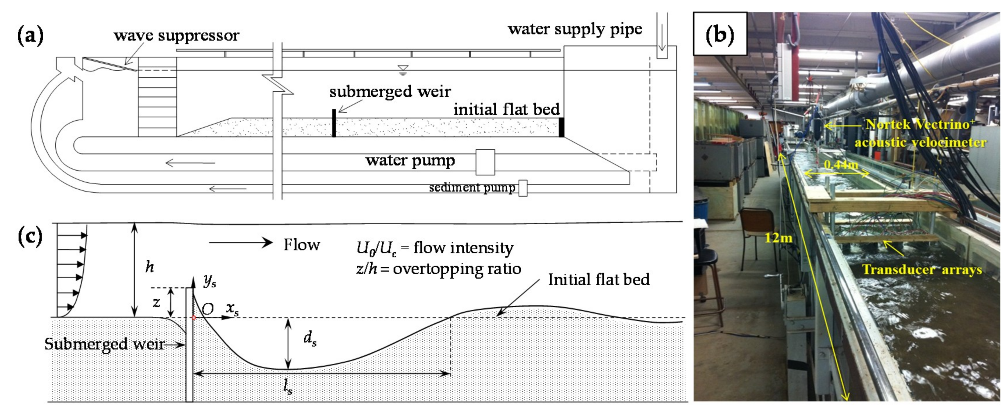
The experiments were carried out in a 12 m long, 0.3 m deep, and 0.44 m wide glass-sided, tilting flume in the Hydraulic Laboratory at the University of Auckland. The schematic of the flume is shown in Figure 1a and the detailed description of the flume can be found in [3]. The sediment used in the experiments was a uniform coarse sand with median diameter, d50 = 0.85 mm, and relative submerged particle density, ∆ = 1.65. The weir used in the experiments was a 10 mm thick rectangular plastic plate, with the same width as the flume. A constant flow depth, h = 150 mm, was maintained for all the experiments, and three weir heights, z = 30 mm, 40 mm, and 50 mm, were used, which resulted in three different overtopping ratios z/h = 0.20, 0.27, and 0.33, respectively. In total, five clear-water scour tests were conducted. The detailed experimental conditions are shown in Table 1. For all the tests, the velocity profiles of the approach flow upstream of the weir were measured by using a three-component, downward-looking Nortek Vectrino+ acoustic velocimeter on the centerline of the flume (see Figure 1b). For each point measurement, two minute samples were collected with a sampling rate of 200 Hz. After the flow measurements, all the raw velocity data from the velocimeter were filtered by using WinADV [26], so that low quality data that had spikes, SNR (signal-noise ratio) < 15 or COR (correlation) < 70, were removed [27]. The average approach velocities, U0, were estimated from the processed velocity profiles. The critical average approach velocities for bed sediment entrainment, Uc, were calculated from the logarithmic mean velocity equation for a rough bed [28]. Since the flow intensities used, which is defined as U0/Uc, are quite small (0.73–0.92), the local water level rise at the weir for all the tests is negligible.
All the experiments were started with a flat bed. The three-dimensional scour geometry downstream of the weirs was measured by using a Seatek Multiple Transducer Array (MTA) system as a function of time for each clear-water scour test. The MTA system comprises 32 transducers, which can be used to detect the distance from the transducers’ surface to a reflective object (bed surface) under the water. The measuring accuracy of the MTA is ±1 mm. In this study, a total of 25 transducers were used to measure the scour profiles. As shown in Figure 1, the transducers were mounted in a rectangular grid on a moving carriage on the top rail of the flume. For each scour profile measurement, the MTA was operated at 5 Hz and could scan the whole scour region within one minute. The detailed arrangement of the transducers and bed profile contouring method can be found in [3]. After the 3D bed profile contouring, the maximum scour depth ds, scour length ls, and scour volume Vs were obtained from the processed 3D scour geometry by using a compiled MATLAB code [3].
3. Results and Discussion
3.1. Temporal Evolution of Scour Depth and Scour Length
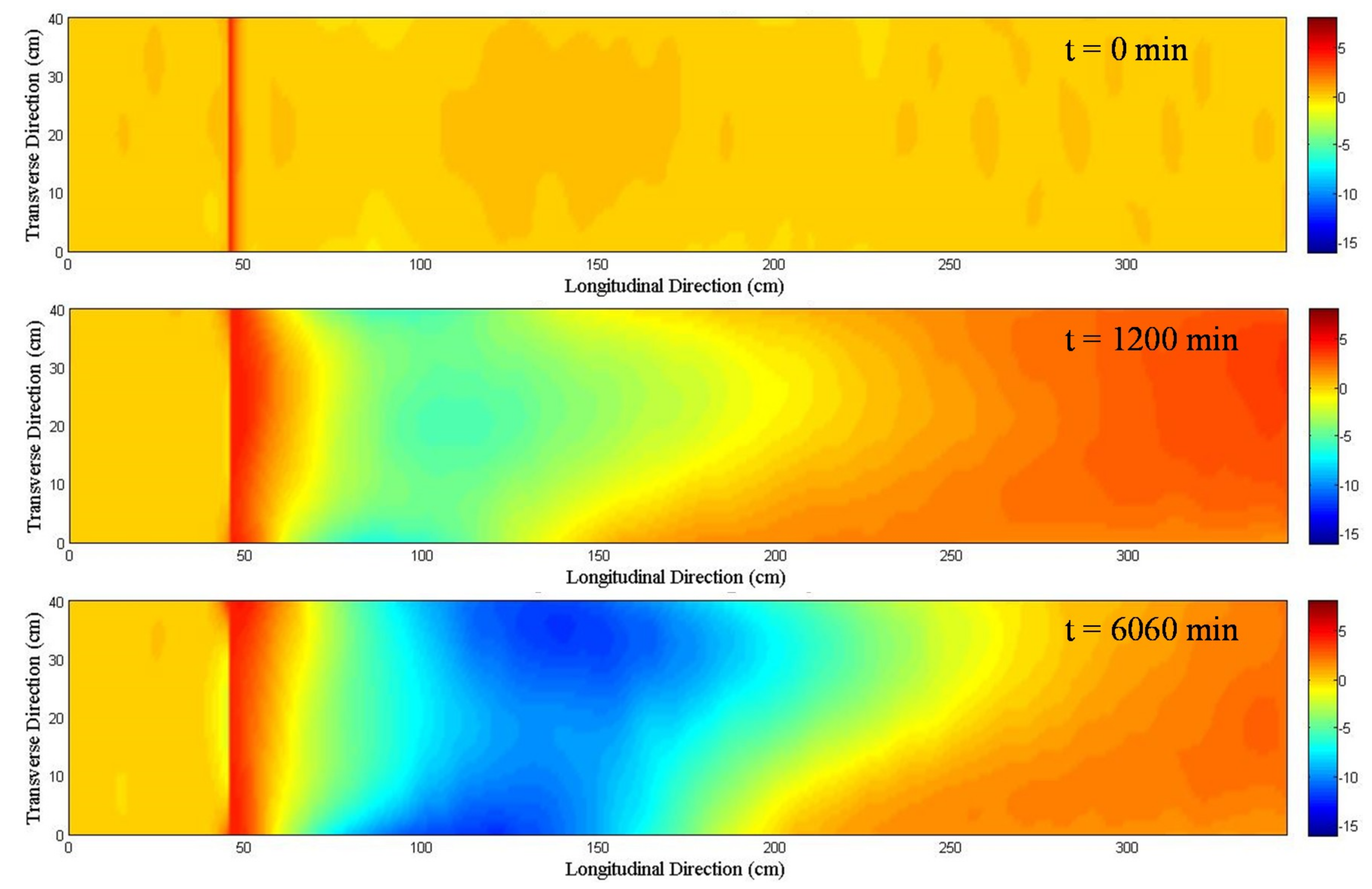
The 3D bed geometry at three different stages of the scour hole development for Test CS2 is shown in Figure 2.
The maximum scour depth downstream of the weir, which is located at longitudinal distance = 50 cm in the figure, occurs close to the weir at the beginning of each test before moving downstream as the scour hole develops. Although the tests were conducted in the straight flume with a 2D weir, the scour hole that forms downstream of the weir exhibits 3D characteristics. The maximum scour depth in the developing scour hole downstream of the weir was found to be close to the flume sidewalls rather than along the centerline of the flume. This is due to the secondary flows in the transverse sections of the flume. According to previous studies [3], the secondary flows are characterized by paired circular flow cells, which are quasi-symmetrically located on both sides of the centerline sand ridge.
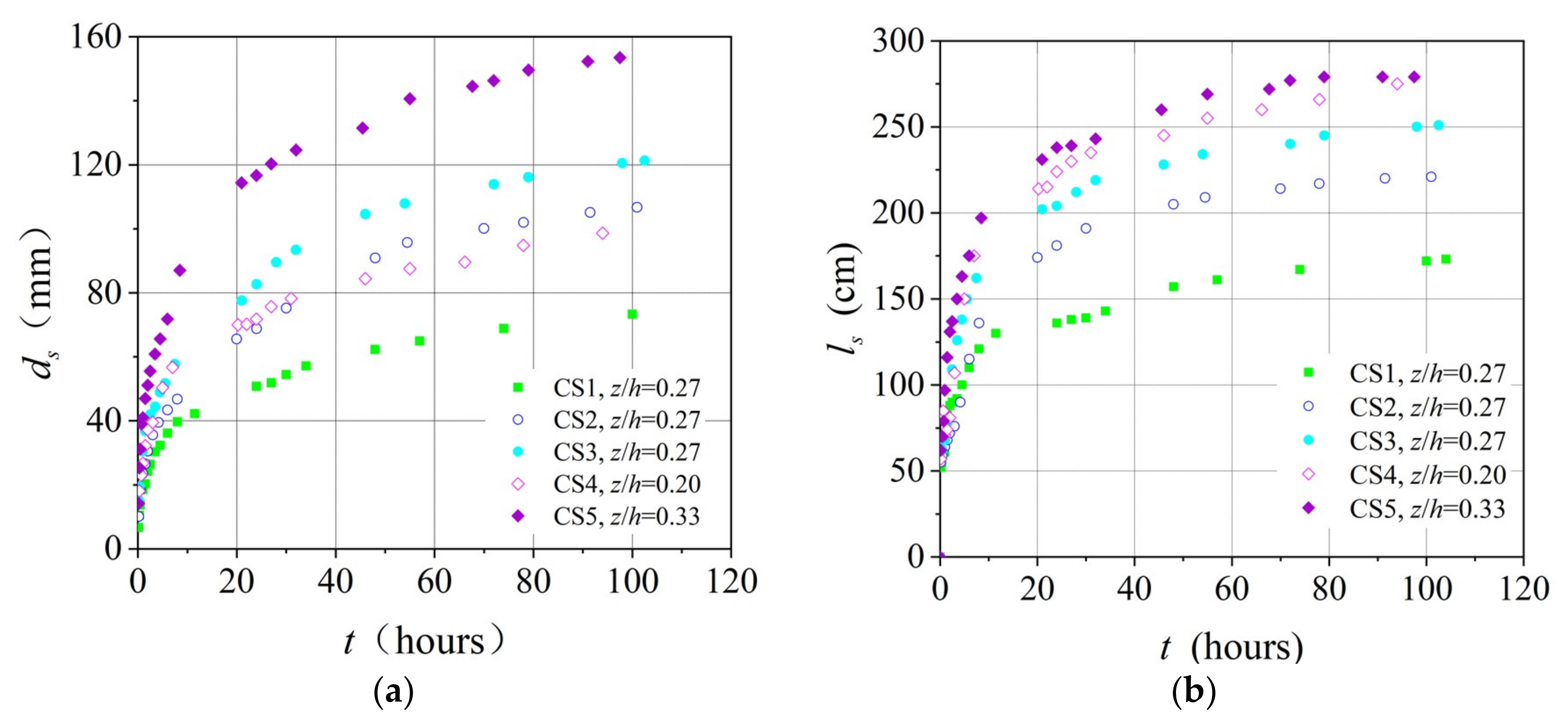
The temporal evolution of scour depth and scour length for all the tests is shown in Figure 3. The results show that the maximum scour depth and scour length develop very quickly in the first 20 h, before progressing at a decreasing rate. This trend is consistent with local scour at other structures, such as monopile foundations, submarine pipelines, etc. [29,30,31,32].
Due to the insufficient scour time, none of the tests, arguably, has reached the final equilibrium stage (see Figure 3a). The equilibrium clear-water scour depth, which is reached asymptotically with time, may take a very long time to form, perhaps infinite time [24]. Therefore, the final equilibrium scour time and depth will not be discussed in this paper. As shown in Figure 3a, the development of scour depth, ds, is influenced by the flow intensity, U0/Uc, and overtopping ratio, z/h. The increase of U0/Uc or z/h accelerates the scour rate and increases the magnitude of scour depth. Figure 3b shows the temporal development of scour length ls. The trends are similar to those in Figure 3a. The development rate and magnitude of ls are affected by U0/Uc and z/h. However, the influence of the overtopping ratio z/h on ls appears to be less significant (see data trends of Tests CS4 and CS5). It should be noted that the values of U0/Uc for Tests CS3, CS4, and CS5 are not exactly the same in this study, thus more work is needed to determine clearer effects of overtopping ratios on the scour dimensions.
Over the past decades, extensive studies [24,30,31,33,34,35] have shown that exponential functions could be used to describe the temporal evolution of clear-water scour process around a variety of hydraulic structures, such as bridge piers, bed sills, abutments, etc. The typical form of the exponential function is as follows:
where Ys = scour dimension (depth or length) at any time t; Yse = scour dimension (depth or length) at the equilibrium stage; T = time scale (represents the equilibrium scour time in most cases); and C, n = coefficient and exponent to be determined experimentally. Considering the universality of Equation (1), it is reasonable to adopt the same form for describing the time evolution of clear-water scour at submerged weirs. However, unlike previous studies, the scour processes in this study may not have not reached equilibrium, i.e., the parameters Yse and T are not available to fit Equation (1). As mentioned in the previous paragraph, the temporal evolution of scour dimensions was found to be significantly influenced by the magnitude of weir height z, thus the length scale z may be an appropriate parameter to substitute for the parameter Yse in Equation (1). Therefore, in this study, Equation (1) is modified as follows:
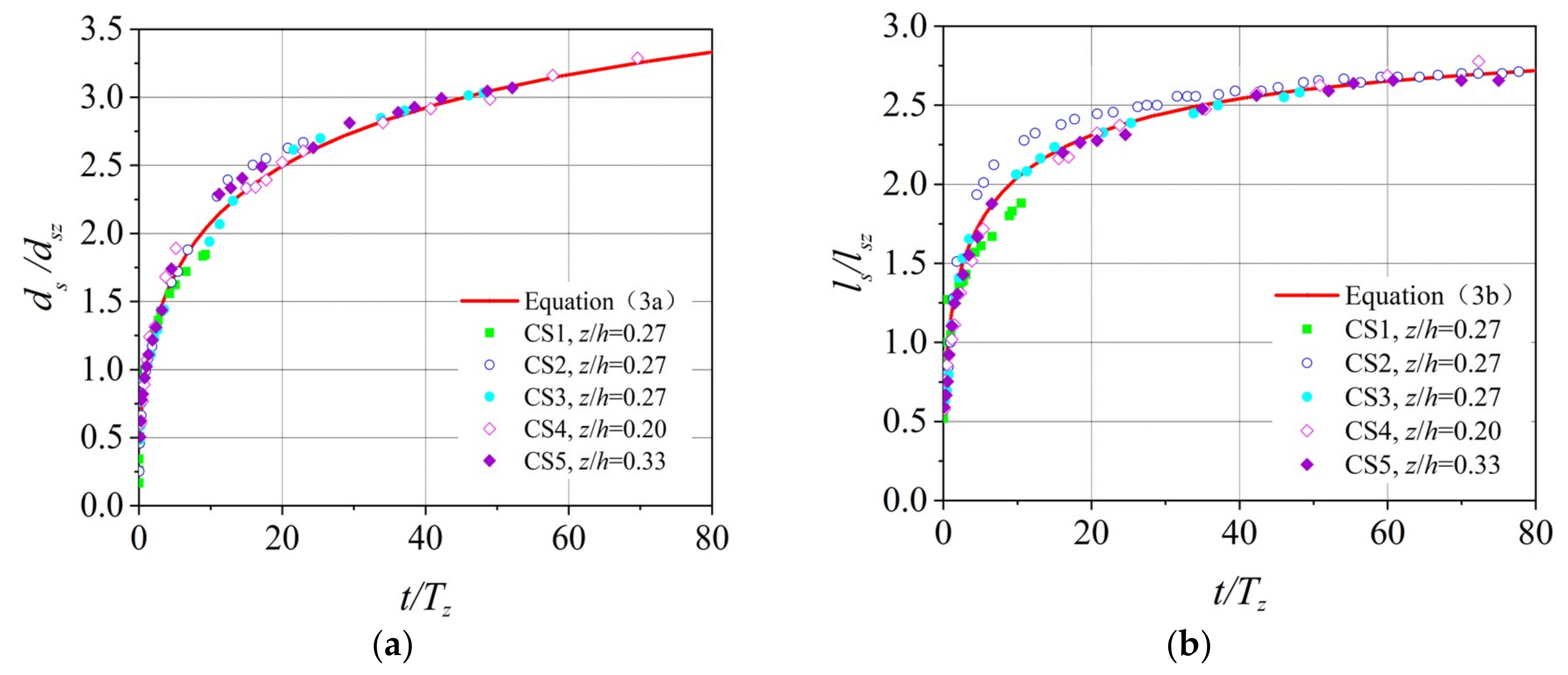
where Tz = characteristic time at ds = z; Ysz = scour dimension (depth or length) at Tz (estimated by interpolating the observed data in Figure 3a); C1, C2, and n = coefficients and exponent to be determined experimentally. Based on the experimental data in Figure 3 and the form of Equation (2), the temporal evolution of scour depth and scour length can be derived as follows:
where dsz and lsz = scour depth and scour length at Tz, respectively. Figure 4 shows ds/dsz and ls/lsz versus t/Tz with an excellent fit. The regression analysis yielded coefficients of determination of R2 = 0.994 and 0.976 for Equations (3a) and (3b), respectively. This indicates that Equation (3) has a high adaptability for the prediction of the scour dimensions downstream of submerged weirs in clear-water scour conditions.
It may also be inferred from Equation (3) that the final equilibrium scour depth dse = 4.22dsz = 4.22z and scour length lse = 2.93lsz when the scour time t approaches infinity. However, this simply is an inference at this stage; its verification by more data with sufficiently longer experimental time is needed in future studies.
3.2. Temporal Evolution of Scour Hole Profiles
It is observed that when the scour process downstream of the submerged weir moves into the slow development stage (t > 20 h in this study, see Figure 3), the scour patterns exhibits a high similarity in spite of the different experimental conditions. This is similar to the scour process downstream of bed sills [11,22]. To further explore this similarity, an empirical model is proposed in this section to predict the temporal evolution of the scour hole profile along the centerline of the flume. Based on this model, hydraulic engineers may design the scour countermeasures downstream of submerged weirs more economically. In this study, ys and xs are, respectively, defined as the vertical and longitudinal coordinates for describing the scour hole measured with respect to the origin O, as shown in Figure 1c. Based on the experimental data analysis, the temporal evolution of the dimensionless scour hole profile can be described as:
where ys (t) and xs (t) = vertical and longitudinal coordinates for describing the scour hole measured with respect to the origin O at any time t (> 20 h); ys,m (t) and xs,m (t) = maximum vertical and longitudinal coordinates of the scour profiles at any time t (>20 h), respectively, i.e., ys,m (t) = −ds (t) and xs,m (t) = ls (t); m1, m2, m3 = coefficients. By fitting the experimental data to Equation (4), the following prediction equation for describing the temporal evolution of the scour hole profile is obtained:
The coefficients of determination, R2 = 0.903. Comparisons of the results obtained from the proposed Equation (5) with the experimental data in this study are shown in Figure 5. It can be seen from the figure that the proposed equation may be used to predict the temporal evolution of scour hole profiles well.
3.3. Relationship between Scour Dimensions
The temporal development of the scour volumes for all the tests was extracted from the scour contour profiles. Although the secondary flows in the cross sections of the flume influence the shape of the scour hole in the transverse direction, the scour hole that forms downstream of submerged weirs can still be approximately regarded as two-dimensional. The mean longitudinal scour area, As, of the scour hole downstream of the weir can be approximately considered to be a triangle. Therefore, the scour area As can be expressed as:
where b = weir width, B = coefficient to be determined.
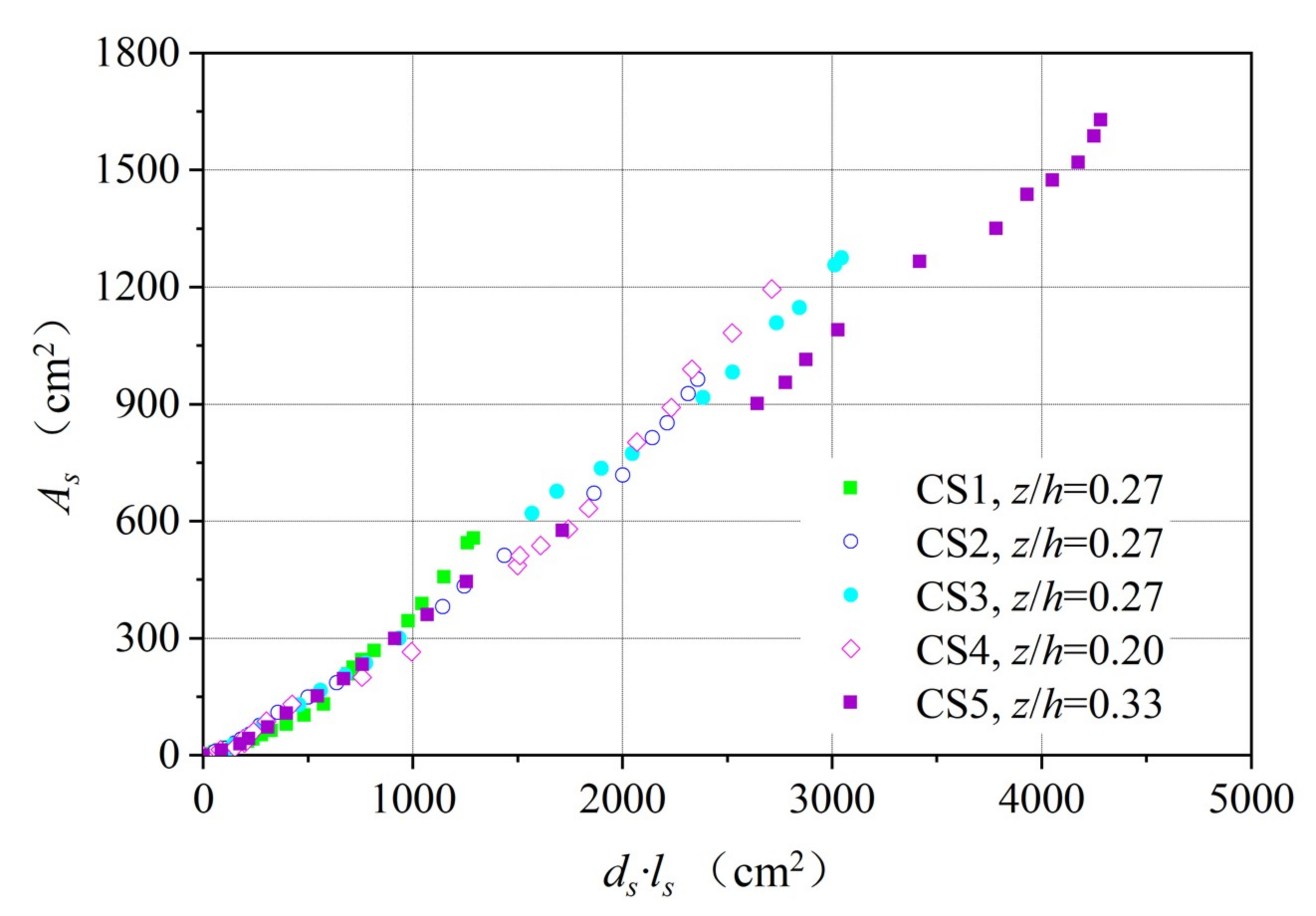
Figure 6 plots the relationship between the scour area, As, and the product of ds and ls. It can be seen that the data trends are linear for all the tests, which may be used to infer that the assumed form of Equation (6) is valid and that the scour hole profiles exhibit geometric similarity.
For all the tests, the flow regimes over the submerged weir were surface flow regime. Under this flow regime, the flow remains as a surface jet downstream of the weir; and the scour hole downstream of the submerged weir is caused by the increasing jet thickness and turbulence mixing with the tailwater [17,19]. As indicated in [11], the geometric similarity of the scour hole profiles can be affected by the jet thickness and drop ratio. Therefore, the coefficient B could be expressed as a function of the overtopping ratio:
Substituting Equation (7) into Equation (6) yields:
where e1 and e2 are coefficients to be determined. A regression analysis is carried out by using the data in Figure 6, which yields e1 = 0.308 and e2 = −0.156 with a coefficient of determination of R2 = 0.991. The final form of Equation (8) is as follows:
A comparison of the measured and calculated averaged longitudinal scour area is shown in Figure 7, which implies that the fitted Equation (9) can provide a good estimate of the scour area downstream of a 2D submerged weir. The area of the computed final scour hole may be used as the area for rock placement as a type of armoring countermeasure against scour.
4. Conclusions
This paper presents an experimental study on the temporal development of scour downstream of submerged weirs. Observations show that the dimensions of scour holes downstream of a submerged weir develop very quickly in the initial stage, before progressing at a decreasing rate until the equilibrium is reached. The increase of the flow intensity or overtopping ratio accelerates the scour rate and increases the scour magnitude. Exponential equations were developed to estimate the temporal variation of the scour depth and scour length downstream of the submerged weir. The geometrical similarity of scour holes downstream of the weir was observed in the tests, and an empirical model for describing the temporal evolution of the scour hole profile was developed. A relation between the scour areas and scour dimensions was also proposed. The present study is useful in development of models capable of estimating scour depth downstream of weirs in rivers or coastal areas, for which the overtopping conditions are very common. The proposed equations for scour hole dimensions, profiles, and areal sizes will be good tools for hydraulic engineers in the design of scour countermeasures.
Author Contributions
D.G. conceived, designed and performed the experiments; all authors contributed to analysis of the data, writing and discussion of the paper.
Funding
This work was funded by the Young Scientists Fund of the National Natural Science Foundation of China (grant number 51709082) and the Fundamental Research Funds for the Central Universities (grant number 2018B13014).
Acknowledgments
The first author would like to thank Bruce W. Melville and Jian-Hao Hong for their helpful advice and technical support. The authors would also like to thank The University of Auckland for providing the experimental facilities for this study.
Conflicts of Interest
The authors declare no conflicts of interest.
References
- Breusers, H.N.C.; Raudkivi, A.J. Scouring; Balkema: Rotterdam, The Netherlands, 1991. [Google Scholar]
- Guan, D.; Melville, B.; Friedrich, H. Bed load influence on scour at submerged weirs. In Proceedings of the 35th World Congress of IAHR, Chengdu, China, 8 September 2013. [Google Scholar]
- Guan, D.; Melville, B.W.; Friedrich, H. Flow Patterns and Turbulence Structures in a Scour Hole Downstream of a Submerged Weir. J. Hydraul. Eng. 2014, 140, 68–76. [Google Scholar] [CrossRef]
- Wang, L.; Melville, B.W.; Whittaker, C.N.; Guan, D. Effects of a downstream submerged weir on local scour at bridge piers. Hydro Res. 2018, 20, 101–109. [Google Scholar] [CrossRef]
- Tregnaghi, M.; Marion, A.; Coleman, S.; Tait, S. Effect of Flood Recession on Scouring at Bed Sills. J. Hydraul. Eng. 2010, 136, 204–213. [Google Scholar] [CrossRef]
- Bormann, N.E.; Julien, P.Y. Scour Downstream of Grade-Control Structures. J. Hydraul. Eng. 1991, 117, 579–594. [Google Scholar] [CrossRef]
- Lenzi, M.A.; Marion, A.; Comiti, F.; Gaudio, R. Local scouring in low and high gradient streams at bed sills. J. Hydraul. Res. 2002, 40, 731–739. [Google Scholar] [CrossRef]
- Marion, A.; Lenzi, M.A.; Comiti, F. Local scouring at grade-control structures in alluvial mountain rivers. Water Resour. Res. 2003, 39, 39. [Google Scholar] [CrossRef]
- Marion, A.; Lenzi, M.A.; Comiti, F. Effect of sill spacing and sediment size grading on scouring at grade-control structures. Earth Surf. Process. Landforms 2004, 29, 983–993. [Google Scholar] [CrossRef]
- Ben Meftah, M.; Mossa, M. Scour holes downstream of bed sills in low-gradient channels. J. Hydraul. Res. 2006, 44, 497–509. [Google Scholar] [CrossRef]
- Marion, A.; Gaudio, R.; Tregnaghi, M. Affinity and similarity of local scour holes at bed sills. Water Resour. Res. 2007, 43, 11417. [Google Scholar] [CrossRef]
- Tregnaghi, M. Local Scouring at Bed Sills under Steady and Unsteady Conditions. Ph.D. Thesis, Università degli studi di Padova, Padova, Italy, 2008. [Google Scholar]
- Chinnarasri, C.; Kositgittiwong, D. Laboratory study of maximum scour depth downstream of sills. Proc. ICE Water Manag. 2008, 161, 267–275. [Google Scholar] [CrossRef]
- Lin, B.S.; Yeh, C.H.; Lien, H.P. The experimental study for the allocation of ground-sills downstream of check dams. Int. J. Sediment Res. 2008, 23, 28–43. [Google Scholar] [CrossRef]
- Tregnaghi, M.; Marion, A.; Bottacin-Busolin, A.; Tait, S.J.; Bottacin-Busolin, A. Modelling time varying scouring at bed sills. Earth Surf. Process. Landforms 2011, 36, 1761–1769. [Google Scholar] [CrossRef]
- Guan, D.; Melville, B.; Friedrich, H. A preliminary study on scour at submerged weirs in live bed conditions. In Proceedings of the 7th International Conference on Fluvial Hydraulics (River Flow), École polytechnique fédérale de Lausanne, Lausanne, Switzerland, 13 September 2014. [Google Scholar]
- Guan, D.; Melville, B.; Friedrich, H. Live-Bed Scour at Submerged Weirs. J. Hydraul. Eng. 2015, 141, 04014071. [Google Scholar] [CrossRef]
- Guan, D. Scour at Submerged Weirs. Ph.D. Thesis, The University of Auckland, Auckland, New Zealand, 2015. [Google Scholar]
- Guan, D.; Melville, B.; Friedrich, H. Local scour at submerged weirs in sand-bed channels. J. Hydraul. Res. 2016, 54, 1–13. [Google Scholar] [CrossRef]
- Tregnaghi, M.; Marion, A.; Coleman, S. Scouring at Bed Sills as a Response to Flash Floods. J. Hydraul. Eng. 2009, 135, 466–475. [Google Scholar] [CrossRef]
- Wang, L.; Melville, B.W.; Guan, D.; Whittaker, C.N. Local Scour at Downstream Sloped Submerged Weirs. J. Hydraul. Eng. 2018, 144, 04018044. [Google Scholar] [CrossRef]
- Gaudio, R.; Marion, A. Time evolution of scouring downstream of bed sills. J. Hydraul. Res. 2003, 41, 271–284. [Google Scholar] [CrossRef]
- Wang, L.; Melville, B.W.; Guan, D. Effects of Upstream Weir Slope on Local Scour at Submerged Weirs. J. Hydraul. Eng. 2018, 144, 4018002. [Google Scholar] [CrossRef]
- Melville, B.W.; Chiew, Y.-M. Time Scale for Local Scour at Bridge Piers. J. Hydraul. Eng. 1999, 125, 59–65. [Google Scholar] [CrossRef]
- Lu, J.-Y.; Hong, J.-H.; Su, C.-C.; Wang, C.-Y.; Lai, J.-S. Field Measurements and Simulation of Bridge Scour Depth Variations during Floods. J. Hydraul. Eng. 2008, 134, 810–821. [Google Scholar] [CrossRef] [Green Version]
- Wahl, T.L. Analyzing ADV Data Using WinADV. In Proceedings of the Joint Conference on Water Resources Engineering and Water Resources Planning and Management, Minneapolis, MI, USA, 30 July–2 August 2000. [Google Scholar]
- Goring, D.G.; Nikora, V.I. Despiking Acoustic Doppler Velocimeter Data. J. Hydraul. Eng. 2002, 128, 117–126. [Google Scholar] [CrossRef] [Green Version]
- Melville, B.W. Pier and Abutment Scour: Integrated Approach. J. Hydraul. Eng. 1997, 123, 125–136. [Google Scholar] [CrossRef]
- Guan, D.; Hsieh, S.-C.; Chiew, Y.-M.; Low, Y.M. Experimental study of scour around a forced vibrating pipeline in quiescent water. Coast. Eng. 2019, 143, 1–11. [Google Scholar] [CrossRef]
- Guan, D.; Chiew, Y.-M.; Melville, B.W.; Zheng, J. Current-induced scour at monopile foundations subjected to lateral vibrations. Coast. Eng. 2019, 144, 15–21. [Google Scholar] [CrossRef]
- Wei, M.; Chiew, Y.-M.; Guan, D. Temporal Development of Propeller Scour around a Sloping Bank. J. Waterw. Port Coastal Ocean Eng. 2018, 144, 06018005. [Google Scholar] [CrossRef]
- Link, O.; González, C.; Maldonado, M.; Escauriaza, C. Coherent structure dynamics and sediment particle motion around a cylindrical pier in developing scour holes. Acta Geophys. 2012, 60, 1689–1719. [Google Scholar] [CrossRef]
- Hoffmans, G.J.C.M. Jet Scour in Equilibrium Phase. J. Hydraul. Eng. 1998, 124, 430–437. [Google Scholar] [CrossRef]
- Cheng, N.S.; Chiew, Y.M.; Chen, X. Scaling Analysis of Pier-Scouring Processes. J. Eng. Mech. 2016, 142, 6016005. [Google Scholar] [CrossRef]
- Guan, D.; Chiew, Y.M.; Wei, M.; Hsieh, S.C. Characterization of horseshoe vortex in a developing scour hole at a cylindrical bridge pier. Int. J. Sediment Res. 2019, 34, 118–124. [Google Scholar] [CrossRef]
Figure 1.
Experimental set-up and definition of experiential parameters: (a) schematic of experimental flume, reproduced from [3]; (b) experimental flume and measurement devices; (c) definition of experimental parameters in 2D.
Figure 1.
Experimental set-up and definition of experiential parameters: (a) schematic of experimental flume, reproduced from [3]; (b) experimental flume and measurement devices; (c) definition of experimental parameters in 2D.

Figure 2.
Temporal evolution of bed topography contours (Test CS2) in cm (flow from left to right).

Figure 3.
Temporal evolution of scour depth (a) and scour length (b).

Figure 4.
Temporal evolution of dimensionless scour depth (a) and scour length (b).

Figure 5.
Temporal evolution of dimensionless scour profiles for t > 20 h.

Figure 6.
Relationship between averaged longitudinal scour area and scour hole dimensions.

Figure 7.
Comparison of measured and calculated averaged longitudinal scour area.


Table 1.
Summary of experimental conditions.
| Tests | z (mm) | U0 (m/s) | z/h | U0/Uc | Runtime (min) |
|---|---|---|---|---|---|
| CS1 | 40 | 0.266 | 0.27 | 0.73 | 6240 |
| CS2 | 40 | 0.296 | 0.27 | 0.82 | 6060 |
| CS3 | 40 | 0.313 | 0.27 | 0.86 | 6150 |
| CS4 | 30 | 0.333 | 0.20 | 0.92 | 5640 |
| CS5 | 50 | 0.314 | 0.33 | 0.87 | 5850 |
For all the runs: h = 150 mm, d50 = 0.85 mm, Uc = 0.362 m/s.
© 2019 by the authors. Licensee MDPI, Basel, Switzerland. This article is an open access article distributed under the terms and conditions of the Creative Commons Attribution (CC BY) license (http://creativecommons.org/licenses/by/4.0/).
Share and Cite
MDPI and ACS Style
Guan, D.; Liu, J.; Chiew, Y.-M.; Zhou, Y. Scour Evolution Downstream of Submerged Weirs in Clear Water Scour Conditions. Water 2019, 11, 1746. https://doi.org/10.3390/w11091746
AMA Style
Guan D, Liu J, Chiew Y-M, Zhou Y. Scour Evolution Downstream of Submerged Weirs in Clear Water Scour Conditions. Water. 2019; 11(9):1746. https://doi.org/10.3390/w11091746
Chicago/Turabian StyleGuan, Dawei, Jingang Liu, Yee-Meng Chiew, and Yingzheng Zhou. 2019. "Scour Evolution Downstream of Submerged Weirs in Clear Water Scour Conditions" Water 11, no. 9: 1746. https://doi.org/10.3390/w11091746
Note that from the first issue of 2016, this journal uses article numbers instead of page numbers. See further details here.