Article

Natural Infrastructure Practices as Potential Flood Storage and Reduction for Farms and Rural Communities in the North Carolina Coastal Plain

1
Department of Forestry and Environmental Resources, North Carolina State University, Raleigh, NC 27695, USA
2
Department of Biological and Agricultural Engineering, North Carolina State University, Raleigh, NC 27695, USA
3
College of Design, North Carolina State University, Raleigh, NC 27695, USA
4
North Carolina Foundation for Soil and Water Conservation, Raleigh, NC 27695, USA
5
North Carolina Association of Soil and Water Conservation Districts, Raleigh, NC 27695, USA
*
Author to whom correspondence should be addressed.
Sustainability 2021, 13(16), 9309; https://doi.org/10.3390/su13169309
Submission received: 16 May 2021 / Revised: 4 August 2021 / Accepted: 13 August 2021 / Published: 19 August 2021
(This article belongs to the Special Issue Evidence-Based Solutions for an Agro-Ecological Transition)

Abstract

:
Increased global temperatures resulting from anthropogenically induced climate changes have increased the frequency and severity of adverse weather events, including extreme rainfall events, floods, and droughts. In recent years, nature-based solutions (NBS) have been proposed to retain storm runoff temporarily and mitigate flood damages. These practices may help rural farm and forest lands to store runoff and reduce flooding on farms and downstream communities and could be incorporated into a conservation program to provide payments for these efforts, which would supplement traditional farm incomes. Despite their potential, there have been very few methodical assessments and detailed summaries of NBS to date. We identified and summarized potential flood reduction practices for the Coastal Plain of North Carolina. These include agricultural practices of (1) cover cropping/no-till farming; (2) hardpan breakup; (3) pine or (4) hardwood afforestation, and (5) agroforestry; establishing the wetland and stream practices of (6) grass and sedge wetlands and earthen retention structures, (7) forest wetland banks, and (8) stream channel restoration; and establishing new structural solutions of (9) dry dams and berms (water farming) and (10) tile drainage and water retention. These practices offer different water holding and storage capacities and costs. A mixture of practices at the farm and landscape level can be implemented for floodwater retention and attenuation and damage reduction, as well as for providing additional farm and forest ecosystem services.

1. Introduction

The increasing frequency and intensity of precipitation and river flooding are common indicators of global climate change, causing increased potential for soil erosion and flood damage. Large amounts of flooding caused by heavy rainfall and storms can damage farmers’ crops, displace residents, contaminate the local water supply, disrupt natural ecosystems, and deteriorate infrastructure [1,2]. Flooding is the most frequent natural disaster globally and one of the most devastating in both lives lost and economic damage [3,4,5]. It is expected that the frequency and duration of riverine flooding events will increase in the coming years due to changing patterns in precipitation, continued urbanization, and other changes in land use that affect natural landscapes [5,6,7].
Historically in the United States, flood risk mitigation has relied on engineered structures such as levees and dams, also referred to as “grey infrastructure” [8] (grey refers to the color of the rock or concrete often used in these structures). These practices have been extensively criticized for their adverse effects on aquatic wildlife and ecological processes, such as degrading natural wildlife habitats and the buildup of sediments, leading to water pollution and reduced dam capacity. In addition, dams and levees are particularly ineffective in mostly flat or lightly rolling terrain, since they would need to flood large areas of productive land in order to hold an adequate volume of water to reduce flooding and would be very expensive to build and buyout inundated farm or urban lands.
There is also growing concern about relying solely on these structures for flood mitigation [3,9,10,11]. The average age of the 90,580 dams in the United States is 56 years. The number of high-hazard potential dams (those that will cause loss of life if they fail) climbed to nearly 15,500 in 2016, of which 2179 were considered deficient [12]. The condition of the nation’s levees is largely unknown. Over the next 10 years, an estimated USD 125 billion is needed to keep existing flood control infrastructure in satisfactory working condition. In North and South Carolina, 83 dams failed from October 2015 to November 2017, and 20 dams in North Carolina failed during Hurricane Matthew in 2016 [13,14].

2. Nature-Based Solutions

Natural infrastructure, also known as nature-based solutions (NBS), has emerged across the U.S. to provide potential practices that can simultaneously reduce flooding, improve water quality, enhance biodiversity, and address food security [15]. Modern natural infrastructure flood management is a relatively new concept, arising in the late 1990s, and is worthy of further consideration [16]. However, while this is perceived as a new concept, it was identified presciently more than 70 years ago by conservationist Ding Darling as a better concept than massive dams in Iowa:
“Darling had what he thought was a better idea, backed by experience, knowledge and successful demonstration projects. In a hearing conducted in 1950, in conjunction with plans to build Iowa’s Red Rock Reservoir, Darling testified: ‘We have ample proof on demonstration areas that runoff can be stopped before the waters reach the rivers and thereby save not only the water but the soil which is washed off with it. On such demonstration areas we have the triple benefit of flood control, soil conservation and restocking of our subterranean water table.’”
([17], p. 260)
More recently, natural flood management is the alteration, restoration, or use of landscape features to reduce flood risk [9]. By working with landscapes to slow and detain water runoff from heavy precipitation events, the stormflow hydrograph can be desynchronized, decreasing the high flows of rivers after heavy precipitation events [18]. These practices also are referred to as flood attenuation approaches—slowing down the release of water after major storm events. Promising landscape alterations include the creation or restoration of wetlands, implementation of various agricultural best management practices, and earthen and vegetation “structural” practices that integrate flood defenses within landscapes to temporarily detain excess water [9,19,20]. As noted by Ding Darling, small microstructures were commonly used to capture rainwater before the modern intensification of agriculture. More purposeful and well-planned efforts could be renewed to address such increased problems in the current era.
In 2016, the International Union for Conservation of Nature (IUCN) defined NBS as “actions to protect, sustainably manage and restore natural or modified ecosystems that address societal challenges effectively and adaptively, simultaneously providing human well-being and biodiversity benefits [15]”. In addition, the U.S. National Oceanic and Atmospheric Administration (NOAA) considers natural infrastructure an “effective solution for minimizing coastal flooding, erosion, and runoff, as do man-made systems that mimic natural processes [21]”. NOAA also states that natural infrastructure initiatives are profitable and cost-effective for safeguarding coastal communities. The New Climate Economy’s 2018 report recommends natural infrastructure, such as forests and wetlands, for providing flood control [22]. Many countries, including Australia, New Zealand, and Indonesia, have already adopted NBSs such as better management of forests and mangroves. These countries have seen positive impacts on global climate and economic benefits [23,24]. Belgium has recently applied NBS methods by reconnecting rivers to the floodplains in order to improve the natural capacities of the floodplains and increase social co-benefits and biodiversity [25].
There are many types of NBS that restore natural landscapes. Such projects can mitigate flooding and enhance the habitats throughout the watershed. Not only is natural infrastructure an advantage for water quantity, but it is also beneficial for ecological processes and biodiversity, such as protecting downstream ecosystems and removing harmful pollutants from runoff; serving as critical habitat for wildlife; functioning as a sink for harmful greenhouse gas emissions; or generating revenues for landowners via crop or wood production [15]. These NBS practices must fit well within the existing physiographic landscape features, land uses, and infrastructure in order to be successful. They must strive to modify existing agricultural and built environments to restore more natural resilience and adaptability to increasingly severe climate changes and adverse weather events.
As global climate change exacerbates flooding problems, adapting to new NBSs and institutional arrangements to encourage their implementation on rural lands is essential for flood mitigation and resilience. These practices refer to a subset of NBSs that can be implemented on farm and forest lands to reduce runoff and downstream flooding and could potentially receive ecosystem payments for these efforts, which will supplement traditional farm incomes and replace the traditional infrastructure. We have initiated research in North Carolina about nature-based solutions, coupled with conservation payments to rural landowners to implement these practices, which we have termed “FloodWise”. This review of the appropriate biophysical practices is one component of that line of research.
FloodWise practices may benefit farms, forests, biodiversity, individual landowners, and local downstream communities. Some are existing farming methods that are beneficial for water storage, and others are relatively new practices designed specifically for mitigating floods. In many cases, the practices are used concurrently for increased resilience. Landowners may already incorporate some of these practices, but with further education, outreach, and financial incentives, many more could adopt them to increase farm income and mitigate flooding. However, there have been almost no methodical and detailed summaries of rural natural infrastructure practices to date, which we sought to redress with this research. The following questions guided our study:
  • What are the most effective natural infrastructure practices that can be used for rural lands in North Carolina?
  • What are the strengths and weaknesses of each of the selected natural infrastructure practices?
  • Can the identified flood disaster mitigation practices be effective at the individual practice level for individual farms?
  • Can the identified flood disaster mitigation practices be effective in aggregate at the downstream watershed or community level?
  • What are the co-benefits of natural infrastructure flood mitigation practices for water quality protection?

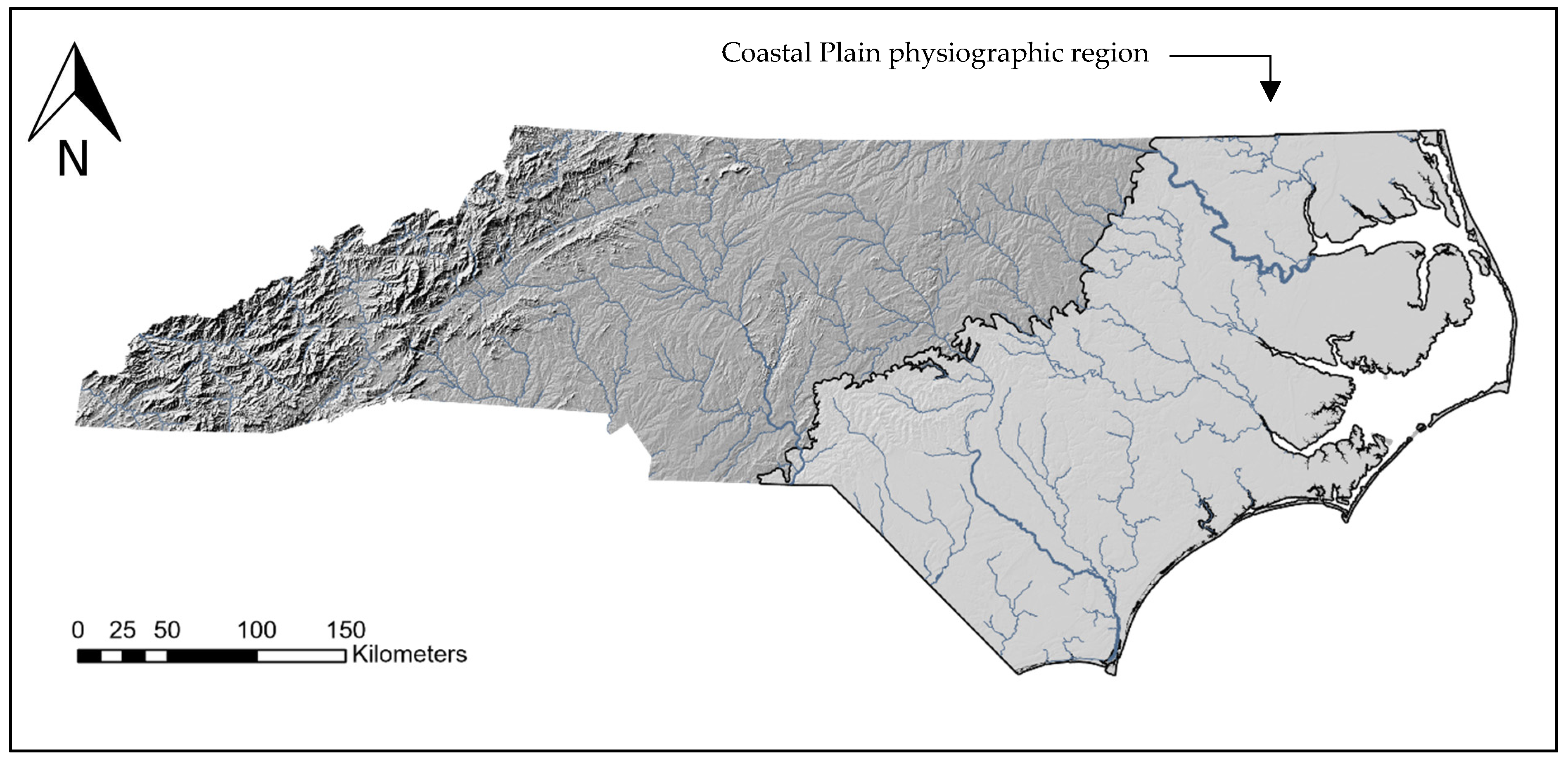
3. North Carolina Coastal Plain
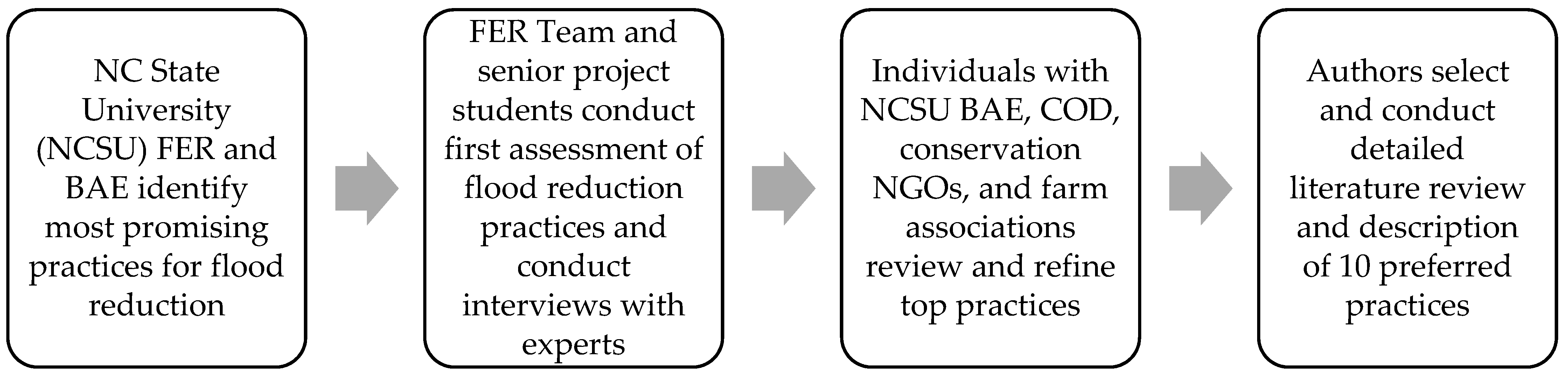
In North Carolina, hurricanes are one of the most frequent and devastating climate-related hazards to the state’s environment and economy compared to other natural hazards. Hurricane Matthew in 2016 and Hurricane Florence in 2018 hit the same urban and agricultural communities in eastern North Carolina. These two storms caused the loss of 85 human lives and damages of USD 17.6 billion for the state; from Hurricane Florence alone, NC experienced approximately USD 1 billion in tobacco, corn, soybean, cotton, chicken, turkey, and hog losses [26]. The areas that were hit the hardest commonly consisted of low-income and agricultural communities. The regions experienced prolonged flooding that completely inundated farmland for weeks after the hurricanes passed. The floods also caused massive pollution and adverse effects from sediment, farm sewage ponds, and chemical runoff, adversely impacting shellfish and fish habitat, human drinking water supplies, coastal waters and beaches, and more.
Our NBS assessment focused on the Coastal Plain of eastern North Carolina. It is prone to riverine flooding due to its relatively flat topography and slow-moving rivers, and the current flood mitigation infrastructure is insufficient (Figure 1). A recent survey in North Carolina indicates that 11% of its dams are unsatisfactory or inadequate [27]. Additionally, land-use changes have exacerbated flooding issues, including the alteration of natural landscapes within the watersheds of the major rivers due to new development towards the coastal region and agricultural expansion [6]. This region of North Carolina is representative of 75 million hectares (188 million acres) of Coastal Plains in the U.S. South’s Atlantic and Gulf coasts, extending from the Virginia coast southward through the Florida peninsula, then along the Gulf coast to Texas [28]. This entire region has relatively similar topography, vegetation, ecosystems, climatic conditions, as well as similar problems with frequent flooding of low-lying topography by hurricanes or other major storm events. Riverine flooding issues related to flatter terrain also extend more broadly across the nation and, indeed, the world.
North Carolina is currently developing a comprehensive strategy for reducing its vulnerability to climate change. The strategy relies partially on nature-based solutions that conserve, restore, and manage its natural and working lands to build climate change resilience in communities and ecosystems and sequester carbon while also meeting other economic, ecological, and societal goals [29].

4. Methods

Iterative NBS Scoping Process

The modern era of natural infrastructure and nature-based solutions is quite new, so the first research task was to determine which existing or new conservation and NBS practices were appropriate in North Carolina for flood reduction and attenuation. The 14 co-authors employed an iterative scoping process using scientific documents, refereed papers, expertise of practitioners, and practical knowledge of our research team to identify the most promising NBS practices (Figure 2). First, the co-authors from the NC State University (NCSU) Department of Forestry and Environmental Resources (FER) and Department of Biological and Agricultural Engineering (BAE) identified a list of 18 possible NBS practices for flood mitigation after consultation with other experts, farm association experts, environmental engineers, and researchers. The original list of 18 practices is shown in Appendix A. Next, co-authors from FER and six NCSU Environmental Science (ES) senior project team students completed a semester-long project with an extensive literature review on the effectiveness of each of the 18 practices. They conducted interviews with environmental engineering consulting firms to obtain more information on the best practices and their costs. FER and BAE research team members and ES students compiled a list of environmental engineering firms and government conservation agencies as their organizational sample for contacts for individuals to interview about conservation practices and costs. The NC State University Institutional Review Board (IRB) reviewed and authorized the interview protocol and research. Finally, co-authors from NCSU College of Design (COD), NC Foundation for Soil and Water Conservation, scientists with the Environmental Defense Fund, and practitioners with farm associations reviewed the list of selected practices, noting their advantages and disadvantages, and helping refine the best practices and their descriptions.
Based on the literature reviews, interviews, and best professional judgment, the co-authors categorized the 18 practices as “best,” “possible,” or “not promising” for flood mitigation in eastern North Carolina (Appendix A), based on the criteria of (1) probability of flood reduction, (2) costs of practices, (3) percent of flood reduction, (4) likelihood of adoption by landowners, (5) risk of failure, and (6) the interaction of these effects.
We finalized our list and selected the 10 best NBS practices for flood reduction in North Carolina (Table 1). These include agricultural practices of (1) cover cropping/no-till farming, (2) hardpan breakup, (3) pine or (4) hardwood afforestation, and (5) agroforestry; wetland and stream practices of (6) grass and sedge wetlands and earthen flood control structures in water retention basins, (7) forest wetland banks, and (8) stream channel restoration; and structural solutions of (9) dry dams and berms (water farming) and (10) land drainage and water retention with tiling.
The three broad categories range in upfront cost and the ease with which they can be adopted and installed. The agricultural practices are a distinct category of best crop and forest practices with comparatively small barriers to adoption. However, wetland and stream practices require significant earth moving to achieve the new NBS natural state and may include some water management control structures. The structural solutions must employ permanent low-rise dams or tiling, respectively. These 10 practices require varying degrees of establishment and maintenance effort and costs, with wetland water retention basins and the dry dams and berms requiring the largest investments.
Our subsequent research consisted of obtaining extensive details about the 10 preferred practices, including clarifying the practices required and identifying useful names and previous examples of their application. Based on the knowledge of the co-authors, the literature and interview data collected by the ES senior project team, and a detailed literature review of these 10 best NBS practices, we identified their potential or drawbacks for implementation. We also conducted a review of the selected NBS practices for water quality protection.

5. Results

We provide the qualitative results of the scientific review of the 10 most effective flood retention and mitigation practices in North Carolina below. This provides an extensive description and summary of the literature regarding their effectiveness and drawbacks.

5.1. Cover Crops and No-Till

Cover crops are planted on agricultural fields to protect and improve the soil and complement row crop production. A growing body of research indicates that cover crops increase landscape resilience [30,31]. Integrating cover crops into both summer and winter crop rotations can improve water infiltration, decrease soil surface evaporation, and decrease the amount of soil water through plant use [32,33,34,35,36]. Because cover crops are planted after the primary crop is harvested, their benefits for flood control would be primarily limited to winter or early spring when fewer major flooding events occur. However, better soil infiltration conditions and less runoff, in general, may provide moderate benefits throughout the year.
Various plant species can be used effectively as a cover crop. Stormwater runoff decreased by 50% during a corn-growing season by incorporating rye cover crops in silt loam soil [37]. By including chickweed cover crops in a soybean-growing season, stormwater runoff was reduced 44% [38]. Cereal rye cover crops improved water storage when incorporated with maize-soybean crops [34]. Over a seven-year timeframe study, winter rye cover crops were found to improve soil water health and storage for a maize-soybean crop [39]. Winter rye increased soil water retention by approximately 11% [39]. Mixing cover crop species in the same plot can optimize outcomes, especially its benefits to underground water [40].
No-till farming practices increase soil pore space by adding carbon to the soil, which improves water infiltration and storage [41]. Many researchers and practitioners acknowledge the negative impacts of tillage practices on soil and water conditions by leaving no plant residue on the soil surface [42,43]. No-till practices can increase rainfall infiltration and reduce water overland flow and soil erosion during rain events compared to intensive plowing. It also would reduce soil compaction and help improve (reduce) soil density.
Cover cropping and no-till farming can work in tandem, particularly because the proper implementation of cover crops can eliminate the need for tillage [44]. Research has shown that a combination of these practices could be effective at increasing landscape water storage. A 2007 report by the Sustainable Agriculture Research and Education (SARE) program indicated that by incorporating cover crops and no-till farming practices in North Carolina, the landscape could store an additional 91 billion liters (24 billion gallons) of water [45].
The combination of no-till and cover crops has also been shown to benefit farmers through increased production. Leon Moses, the manager of North Carolina A&T State University’s 200-hectare farm in Greensboro, North Carolina, explains that adding cover crops has provided an approximately 40% return on investments [44,45]. By incorporating cover crops, soybean and corn yields increased substantially [46,47]. No-till farming retains soil surface residue and generates the most revenue from crop production [48]. However, there are instances where cover crops have been shown to decrease cash crop yield. Bergtold et al. [44] examined eight studies of cover crops’ effect on subsequent cash crop yield; six had increases of 10–131%, and two had decreases of up to 50%. They identified the termination of the cover crop as a critical factor in crop yield response. A poorly implemented or poorly timed termination will cause cash crops to compete with dying or unaffected cover crops.
Farmers generally understand the benefits of cover crops. A survey of 3500 farmers in Iowa, Indiana, Illinois, and Minnesota revealed that 96% of farmers believed cover crops reduce soil erosion, but only 18% utilized cover crops [49]. This appeared to be due to the extra cost and labor involved. Cover cropping processes must include cutting the last crop, soil preparation, and sowing operations, all of which must be performed within a week [50]. Different tillage practices are used for various reasons, and farmers generally decide which practice to perform to enhance their profitability [51]. Tilling is conducted to prepare the seedbed and prevent and remove weeds. One of the main reasons for implementing tillage practices has been to provide the best layout for seed germination and root growth [51].
Conservation crop farming practices are already used relatively extensively in North Carolina (Table 2). The USDA 2017 Agricultural Census shows that the adoption of these practices in North Carolina is growing slowly [52]. Most NC farms already either use no-till or reduced till practices, with only 30% reporting in the 2017 Census that they use conventional tillage. However, only 11% of NC farmers reported using cover crops. In addition, farmers in North Carolina and the rest of the U.S. may already apply for and receive financial payments for a wide variety of programs and hundreds of individual conservation practices, either through the U.S. Farm Bill or similar state conservation programs. These types of conservation programs could be a model for ecosystem service payments that could be instituted for FloodWise nature-based solutions as well.
North Carolina farmers can help mitigate flooding and improve soil health via cover crops and no-tillage. The primary effect of these practices would be to reduce runoff during the first part of an extreme precipitation event before the soil becomes saturated. Flood modeling has shown that this can reduce the peak flow downstream; however, we are not aware of any published studies that quantify the effects of this additional water storage on downstream flooding.

5.2. Hardpan Breakup

Dense and compacted soil, also known as a hardpan layer, is one of the key issues in crop production [53,54]. The hardpan layer can be found anywhere between 0.1 to 1.0 m under the soil surface. It can be caused by plowing or tilling to the same depth every year, resulting in the underlying soil becoming very compacted. Hardpans can also be caused by heavy traffic of tractors and other machinery, especially in wet weather. Hardpans also may be caused by the use of chemicals that kill important soil microorganisms and by droughts [55].
Research conducted in the Southeastern U.S. indicates that hardpan layers constrain root growth and restrict soil water infiltration and soil aeration, limiting crop yield and increasing erosion and flooding from runoff [54,56]. Breaking up areas where the soil is compacted and root growth is restricted increases soil moisture [54,57]. Chisel plows are attached to tractors and rip the hardpan, allowing for better water infiltration and deeper root growth.
The development of hardpans can also be prevented with no-till practices [58]. No-till farming is desirable on highly erodible land or high clay soils because it can reduce soil erosion and enhance crop establishment [59].
The effectiveness of breaking up hardpans and the subsequent runoff and flood reduction depends on the extent of the hardpan, the permeability of the soil layer above and below it, and the intensity of the precipitation. Where soils are permeable, and the hardpan is extensive, the effectiveness of the break-up can be significant. However, where soils are less permeable or have a less permeable layer relatively close to the surface, such as that found in much of the NC Coastal Plain, the effectiveness of this practice for flood mitigation is more limited.

5.3. Forestry

Forest lands are common throughout eastern North Carolina, with forests comprising about half of the land area in the southern U.S. states from East Texas to Virginia. So, establishing forests may not be considered an innovative runoff reduction practice per se. Furthermore, forestry may already have moderate rates of return, albeit less than conventional pasture and crop farming. Thus, we do not provide an extensive review of forest practices here, which has an extensive body of literature already. Forests generally have higher water infiltration rates, less surface runoff, and erosion, and more transpiration than pastureland or crop land, helping reduce flooding [60]. Forests also provide more biodiversity and require less use of chemicals and fertilizers, enhancing natural ecosystems in situ and downstream.
Converting croplands that are frequently flooded or are on low productivity soils to planted forest stands can provide runoff retention benefits while not significantly reducing economic returns. The use of trees and pasture in frequently flooded fields in eastern North Carolina has been shown to reduce crop losses from flooding. While forests are common, tree planting (afforestation) on marginal crop or pasture lands can reduce floods and increase net income.
As one indicator of water quality and quantity, Richter [60] reported that forest land in North Carolina had an average soil erosion rate of 0.36 metric tonnes per hectare per year, while pastureland averaged 3.8 metric tonnes per hectare year and crop land averaged 10.3 metric tonnes per hectare per year. Forests would have greater erosion rates in the years that they were harvested, ranging from 0.38 to 3 metric tonnes per hectare per year depending on the topography, but these higher rates would decrease within one to three years as forest lands regenerated.
The hydrologic modeling of two North Carolina Coastal Plain watersheds has shown that converting crop and pastureland to forest reduces runoff and downstream flooding after sufficient tree growth has occurred. The degree to which the reduction occurs is dependent on many factors, including the amount of land conversion, the topography, and the soil permeability of the land being converted to forest.

5.4. Agroforestry

Agroforestry integrates farming practices with silviculture by growing trees and crops on the same unit of land or trees and pasture animals on the same unit of land [61]. Much of the research around agroforestry systems has focused on ecosystem benefits. Various studies have provided evidence that agroforestry systems provide more benefits for carbon storage, biodiversity conservation, and water quality enhancement than standard farming practices. The carbon stored in trees and roots can offset livestock methane emissions, resulting in reduced net greenhouse gases. The shade from the trees can help provide thermal regulation for animals, increasing health and reproductive success [62,63].
To a large extent, agroforestry practices are an extension of traditional forest land management practices, which offer more flood water retention benefits. Substantial evidence indicates that forested areas exert some control on the hydrologic cycle [64,65,66]. As previously noted, forests have less erosion and thus produce less runoff that reaches rivers [60], but deforestation generally increases the runoff amount [67]. Multiple studies have suggested that agroforestry systems may offer some benefits for flood control and risk reduction [68,69]. Agroforestry may alleviate flooding through increased uptake of precipitation and facilitate more significant soil profile recharge compared to row crops and pasture. A 2019 meta-analysis of 89 papers discussing water infiltration in agricultural soils indicated that agroforestry increased water infiltration by 59.2 ± 20.9% [70].
In the southeastern U.S., microclimate differences occurred in a typical open pasture system with a young (5–8 years) longleaf pine (Pinus palustris) agroforestry system [71]. Soil water content was significantly higher (26%–98%) in the agroforestry system than in a normal pasture, suggesting that the agroforestry system’s soil was better at holding water. However, a similar study within a mature (18–20 years) loblolly pine (Pinus taeda) agroforestry system found that soil water content was significantly lower (29–77%) over a normal pasture [72]. Looking at the results of both studies, the authors concluded that mature trees’ extensive root systems allow them to utilize the excess water in the system. Water extraction by deep-rooted vegetation reduces groundwater storage and decreases the amount released to streams [73]. However, the magnitude of this change on the stormflow hydrograph likely varies based on vegetation type, climate, soil types, and other factors [74].
Some studies have suggested that agroforestry practices may increase farmers’ income, particularly on poor soil sites. In 2007, a 7-hectacre replicated block agroforestry and silvopasture research and demonstration project was established at the Center for Environmental Farming Systems (CEFS) in Goldsboro, North Carolina,. Researchers tracked the performance of these systems for 13 years to date [75]. The site was a lower-lying field in a bend in the Neuse River, which has flooded frequently and is not highly productive due to poor soils and flooding. A corn/soybean annual rotation was planted between rows of planted trees in the first six years. The crops performed very poorly due to either floods or droughts, but the trees prospered [75]. Since then, warm-season grasses were planted, and by the 10th year, beef cattle have been grazed between the tree rows in rotational grazing, and both the grasses and the trees have grown very well.
There are also some significant agroforestry implementation challenges. Landowners in the southeastern U.S. are hesitant to consider agroforestry due to lack of information or misconceptions [76], and many natural resource professionals and registered foresters (to which farmers may turn to for information) are untrained or unfamiliar with agroforestry systems [77]. Agroforestry practices will usually reduce crop or grass yield due to competition for light and nutrients or due to the selection of tree species usable by crop pests [78]. Some studies have also pointed out that the accumulation of agroforestry waste (i.e., pinecones, seeds, leaves) increases crop pest species populations, provides fuel for wildfires, and contributes to other issues such as eutrophication in water bodies if not properly managed [79].

5.5. Wetland Restoration

Wetland restoration refers to re-establishing a degraded or prior converted wetland to its original hydrologic and vegetative conditions. In our scoping efforts, we identified two types of wetland restoration practices that could be used to retain and store floodwaters. One is the excavation of wetland retention basins in or along waterways using berms and water control structures at the downstream end, and planting with grasses, sedges, and other hydrophytic vegetation. This would require considerable earthwork and berms of one meter tall or more in order to create wetland basins with enough storage volume to substantially reduce stormflows. This was the most extensive and expensive flood mitigation practice identified. A second less intensive but still complex system would be hardwood forest wetland restoration on drained agricultural land, which would require reformation and grading to its original wetland contours, plugging any existing agricultural drainage ditches, and maintaining wetland hydrology with flashboard risers in the ditch outflows.
The time required to restore a wetland can vary; a wetland with marsh vegetation could take three to four years, while forests may take 30 or more years. However, restoring a wetland for flood storage purposes alone is typically quicker as these functions depend primarily on the topography [80]. In a study of the Charles River in Massachusetts (U.S.), the U.S. Army Corps of Engineers (USACE) calculated that the loss of all wetlands in the watershed would result in an additional USD 17 million of flood damage annually [81]. Many wetlands have been degraded by draining or dredging [82,83]. At the time of European settlement in the early 1600s, the area that would become the conterminous United States had approximately 89 million ha of wetlands. About 42 million ha remained in the mid-1980s when wetland protection began [84]. North Carolina alone is estimated to have lost almost 2.2 million about 49% of its pre-European settlement total wetland area, mainly for agriculture [84]. A growing body of research demonstrates the importance of properly maintaining existing wetlands and restoring old wetlands with appropriate, sustainable methodologies [82,85,86,87].
The effect of wetlands on flooding depends on multiple factors, including the wetland location in the landscape, the surrounding topography, and management decisions [88]. However, in general, it appears that floodplain wetlands help mitigate flooding. Wetlands in floodplain regions can delay floodwaters and reduce the flow of water downstream [20], resulting in a reduction in peak flood height. In addition, restoring wetlands with herbaceous vegetation provides coarseness, causing a decrease in stream velocity and sedimentation [89].
Wetland grasses and sedges have fast-growing and dense root matrices that help capture pollutants and as a vital habitat for wildlife. Wetlands also provide many other benefits to human and ecosystem livelihoods, including sustaining biodiversity, sequestering carbon, enhancing water quality, improving downstream aquatic habitat, recharging aquifers, and providing protection from storms [82,90,91,92].
However, wetland restoration is challenging. First, it has not always been met with enthusiasm by landowners. By providing an area of the property for wetland restoration, a landowner may be permanently unable to use the area for non-recreational purposes. Once established, removing or filling the wetland without a permit from USACE is unlawful [93]. If constructing a forested wetland, the full benefits of flood mitigation may not be realized for decades. Restored wetlands may not perform as planned due to inadequate designs, unsuitable site selection, and lack of follow-up on maintenance [94]. To avoid some of these challenges, the North Carolina Wetlands Restoration Program (NCWRP) recommends working with landowners to develop a detailed assessment of the watershed and topography for wetland decision making and implementation [95].
Restored mature floodplain forests can be effective as wetland restoration [96]. Forested wetlands can soak up, transpire, and evaporate a large amount of water. Additionally, in a mature forest system, trees drive a large wood cycle process. Large logs from fallen trees can alter the channel process of a river, either by protecting certain areas from erosion and thus allowing trees to reach a greater size or by directing water in a bank to cause erosion which causes more trees to fall into the channel [97]. The increased mature-forest-driven complexity of the floodplain surface has been shown to increase the lag time for peak floodwaters. The logjams provided by the forest may be effective at reducing peak flood heights [98].
Establishing a typical forested wetland bank on “prior converted” agriculture lands is common for wetland mitigation banking and development offsets. This requires only a modest amount of grading and restoring a current crop field back to a flat wetland site, with some drainage controls, flashboard risers for the ditches, and tree planting to restore the prior wetland functions and values.
In addition, many forests in the Carolinas and the South have already been converted from native hardwood or pine forests, ditched, and drained in the last 70 years, which amount to about 1.3 million hectares on wetland soil types [99]. These ditching and draining practices are no longer allowed without a USACE permit, and indeed, establishing new areas of converted, intensively managed planted pine stands is unlikely. However, existing stands usually already have extensive ditches and water control structures to remove excess water during wet periods of the year and retain water to promote tree growth during dry periods.
Planted pine forests on converted wetlands could easily just have their water management practices modified without much new construction or costs. The owners could draw down the ditch levels and forest water tables before anticipated major flood events; then raise the existing flashboard risers before heavy rainfall begins and then let water out more slowly. This approach would require new research to examine the absorption capacity of drained, planted forests and the amount of extended flooding that could occur without harming trees and industrial forest production.

5.6. Stream Restoration

Most natural streams follow a sinuous pattern. In nature, straight channels are rare [100]. A meandering bend in a stream increases resistance and decreases water velocity [101]. Over hundreds of years, streams have been modified by straightening the channels to move water downstream as quickly as possible and reduce local flooding. However, the compounded effect of many straightened stream channels in a watershed can increase flood risk in downstream locations.
Restoring stream channels to their natural meandering path can reduce the high-water velocity and reduce flooding downstream. One of the most used restoration approaches is natural channel designs (NCD) [101,102,103]. The NCD restoration approach involves reshaping the unstable stream, installing in-stream structures, and re-establishing the hydraulic connection between the stream and its floodplain. NCD also calls for planting riparian vegetation, which can stabilize the stream bank, slow down runoff, and remove pollutants [101,102,103]. The establishment of sequenced riffles and pools maintains the channel’s slope and stability. Water flows over the riffles at low flow, removing fine sediments and providing oxygen to the stream [101].
Not only do NCD approaches slow down water velocity and distribute floodwaters across the floodplain, which can reduce the magnitude of downstream flooding, they have also proven to provide better water quality and wildlife habitats. For example, a study found that re-meandering stream channels and adding riparian vegetation were positively correlated to habitat quality indicators [104].
However, stream NCD practices reduce flooding only modestly and are expensive. A recent stream restoration project completed by the NC State University Department of Biological and Agricultural Engineering estimated approximately USD 738 per meter for practice establishment. A study by the North Carolina’s Department of Environment and Natural Resources from 1997 to 2006 assessed costs of stream restoration projects across the state, finding that the practice cost, on average, USD 794 per meter [105]. In addition, this practice can be very time-consuming [106]. Additionally, altering a stream channel will require extensive coordination with federal and state regulatory agencies to obtain the necessary permits.

5.7. Berms and Dry Dams

One other water attenuation practice that we identified was the use of low height berms of less than a meter—raised, compacted strips of soil or other materials that act as barriers to divert water—with water control structures or flashboard risers as well. We use the term “water farming” for its potential application to temporarily catch and store waters on farms as a new land use, and the prospects of receiving FloodWise conservation payments for doing so. Farmers have employed such small water storage sites, dams, outlets, and risers for centuries to build fields to cultivate crops such as rice paddies, or even almonds in California.
Berms are commonly used in terrace systems implemented across cropland to divert runoff to a stable channel and away from the erodible land downslope. Berms are often coupled with the use of dry dams [107]. Dry dams (also referred to as detention dams) temporarily retain water during high intensity and long duration precipitation events, allowing the catchment area to drain slowly until dry [108]. Holding back runoff from many catchments can desynchronize the storm flow, resulting in less flooding downstream. Dry dam and berm systems have been shown to limit the transport of sediment downstream, which, if it enters a stream channel, can exacerbate flooding.
The ability of berms and dry dams to reduce flooding is mainly dependent on how much runoff is retained and when it is released. For example, the South Florida Water Management District (SFWMD) conducted a pilot program of water storage on agricultural land in the Saint Lucie Watershed in 2013. The pilot’s goal was to store an average annual volume of approximately 11,300 acre-feet of surface water and catch 100 percent of rainfall on the site [109]. From February 2014 to March 2015, both goals were met [109]. Furthermore, this program was popular with agricultural landowners who were paid on a per-acre-foot basis for storing the water.
Researchers and practitioners with the SFWMD have shown that these practices are cost-effective and require minimal time to implement compared to traditional engineering structures [110]. Water quality monitoring has documented that the nutrient loads (e.g., nitrogen) and downstream discharge were reduced while the retained runoff provided a supplemental source for irrigation [109,111]. These practices and successful outcomes were conducive to Florida’s flat topography; we expect similar promising results for eastern North Carolina.
Regular maintenance of dry dams, such as removing sediments and debris, would be required approximately every 10 to 20 years and generally cost five percent of the original construction price [112]. Berms are most successful when other erosion control techniques are utilized, such as cover cropping and no-till. Otherwise, berms can rapidly acquire too much soil to function correctly [113]. Some authors recommend combining this approach with other strategies to mitigate larger floods [114].
This approach of dry dams and berms is similar to centuries-old water management practices used for a few crops such as rice. These establish low-rise water management structures—ditches and risers—across an agriculture landscape. Water is stored for part of a growing season and released at other times. We did not examine this agricultural practice explicitly, but similar to the water management on planted pine stands in the South, this practice could be managed in reverse as well. Water on fields could be released before anticipated major storm events, dammed and collected during the storm, and released more slowly afterward.

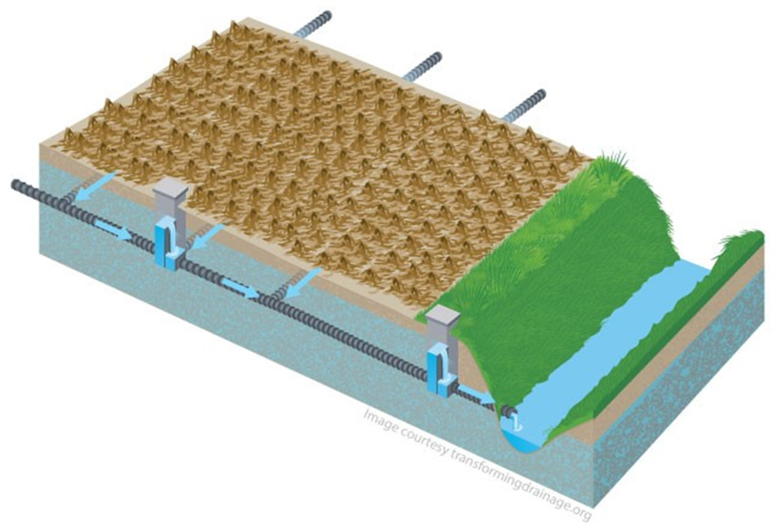
5.8. Land Drainage and Water Retention with Tiling and Terraces

Land drainage systems also could be used for water storage as well as water drainage. There are two types of simple land drainage controls: surface drainage and subsurface drainage. Surface drainage installations remove surplus water from the soil surface. In the past, systems such as tiling and subsurface drainage have been used to drain wetlands for agricultural production, which has increased runoff and flooding. This system has been widely applied and could be useful but would have to be carefully reverse-engineered and used to slow down and store water, not accelerate surface and subsurface runoff. Land drainage systems are well known and understood by farmers and are one of the most inexpensive and most straightforward approaches to control excessive runoff without causing erosion [115].
Excess runoff water is diverted away from erodible sloping ground and into stable waterways via a combination of small berms and channels often referred to as terraces. One type of terrace that uses underground pipes or tiles as stable conveyances to carry the runoff off the land is tile-outlet terraces [116]. Tile-outlet terraces often are designed with upslope runoff storage areas that can retain runoff to help reduce peak runoff rates and downstream flooding [117].
For subsurface drainage, excess water is removed from the soil profile by plastic perforated pipes placed underground to drain the water [115]. Subsurface drainage has been proven to reduce localized flooding by enhancing infiltration. It also allows the soil to dry quicker, which increases soil aeration, nutrients, and biological activity [115]. If the subsurface water is not drained, not only can crops become damaged, but soil can become highly compacted, causing loss of porosity. The overall impact of surface and subsurface drainage, correctly applied, creates healthier soil and increased crop production [118].
However, a downfall of subsurface drainage is that it could prevent groundwater from recharging aquifers because water is not allowed to percolate fully [115]. This may exacerbate flooding in downstream areas since more water is being discharged to surface waterways than otherwise would. It also can result in soil nutrient loss [119]. It is believed that these drainage systems can be improved using simple subsurface control structures. Unlike conventional free-draining systems that remove excess soil water to the drain depth, controlled drainage increases water retention and storage within the soil profile [119].
Figure 3 shows how water control structures can be used in conjunction with tile drainage systems to increase water storage within the soil profile by allowing water to “back up” in the soil to a preset depth before being allowed to overflow into the next tile drainage section [120]. Research conducted in the Midwest (which has extensive tile drain systems) has shown that the use of these simple drainage control structures not only results in a reduction of total drainage volume but can also lead to an increase in crop yields, particularly in drier years [119,121]. These structures are currently being tested and researched on the Albemarle-Pamlico Peninsula in North Carolina and have been found to reduce nitrogen runoff and improve water quality [122].
A potential challenge with introducing these controls is that many free drainage systems were installed decades ago, and not all farmers have mapped them. As land has been subdivided and sold, there is also the issue that some of these systems cross current property boundaries. There have been instances of some farmers installing controls that have caused extensive flooding on their neighbors’ lands. In addition, these systems require continual maintenance over time by removing accumulated sediments and debris from the perforated pipes [123]. Otherwise, the pipes can become clogged and cause localized flooding on the farmland.
Many of these subsurface drain discharge into nearby ditches, which transport runoff to streams and rivers. Similar to the subsurface drainage features, ditch systems can reduce localized flooding while potentially increasing flooding risk downstream. Ditches can be modified with flashboard risers to temporarily slow the flow rate or back up water onto private or public property. However, care would have to be taken to avoid interference with the crops. These simple structures have been shown to reduce downstream flooding risk [124]. Flashboard risers serve both water drainage and irrigation purposes and restrict the flow of runoff and floodwaters [125]. Manale (2000) found, in eight watersheds in Iowa, that installing these simple water-storing controls lessened the risks of floods and increased societal welfare by reducing flood damages downstream [126].
Lastly, Manale [126] recommends implementing a program that requires landowners to utilize flashboard risers to plug the runoff during extensive rainfall. The researcher suggests compensating the landowners for storing water by not investing in an agricultural crop. Manale [126] also indicates that farmland situated in flood-prone areas undergo a contract, enabling compensation for storing water and receiving a bonus for what the landowners may have produced if they were to harvest a crop in that location. This is similar to the Dispersed Water Management Program of the South Florida Water Management District in theory but using a different tool. Storing water in flood-prone regions by using controls such as flashboard risers could reduce the amount of crop insurance and damage assistance elsewhere.
In summary, flood reduction from free draining underground tile and surface ditch drainage systems requires managing the structures for runoff control. The landowners need to be on board to install these features, but they will also need to know how to operate them. Alternatively, if not managed and maintained properly, flooding could increase downstream. This characteristic is the same for any of the structural practices of dry dams and berms, drained forest wetland management, or tiling.

6. Discussion

6.1. Implications for the North Carolina Coastal Plain

A summary of the merits of the 10 selected natural infrastructure practices examined in detail is shown in Table 3. These practices differ in their potential for flood reduction, the time required to establish them, their complexity, cost, compatibility with farm production practices, and co-benefits for water quality. In practice, there is not one specific solution that is best. Practice suitability will depend on their costs, the shape and form of the site and surrounding landscape microclimates and future flood events, farm or forest landowner preferences for adoption, government education and incentives, and government policies that promote or constrain land management and green infrastructure practices.
The agricultural practices include cover cropping/no-tillage, hardpan breakup, afforestation, and agroforestry; these practices improve runoff reduction, groundwater recharge, and soil permeability. Recent studies in Northwest Europe on the effects of no-till farming and related practices have shown that when used individually and collectively, they hold vast potential for significantly reducing soil erosion from farmlands and enhancing soil porosity [127]. Cover cropping and no-till farming directly impact the structure of the soil and its ability to absorb water. Although it is difficult to determine the scale of benefits in these complex systems, understanding the biophysical functions involved in these practices can highlight their potential co-benefits; through agroforestry, the biophysical properties of tree roots improve the water uptake rate, the capacity for groundwater recharge, and evapotranspiration [128]. When implemented and managed properly, strategic combinations of afforestation, agroforestry, no-till farming, cover cropping, and hardpan breakup can provide water quality and runoff reduction benefits through improvements to soil structure. However, long-duration and intense rainfall (i.e., hurricanes) can often overwhelm these practices rendering them insufficient for preventing damage from major storms.
Wetland and stream practices include wetland restoration, flood-tolerant forest and grass species, large wetland retention basins, and natural stream channel restoration. These practices restore the natural features of the landscape that facilitate ecological processes which store and filter water and can use natural meandering streams or structures such as berms, spillways, and flashboard risers to impound, store, and release floodwaters. Riverine floodplain wetlands serve as essential ecosystems that contribute to water purification, sediment and nutrient retention, and pollutant reduction and act as natural buffering systems [129]. The ecosystem services provided by wetlands and streams can offer several co-benefits beyond flood reduction, including less erosion, less pollution by farm pesticides and herbicides, less water-borne animal or human waste, better fish and shellfish habitat, and improved drinking water. Understanding the role of ecohydrology in stream and wetland management practices, which focuses on the ecological processes that occur within the water cycle, is crucial for maximizing co-benefits of these practices; adopting an ecohydrological framework in wetland and stream restoration can help reduce the transportation of sediments and pollutants by flood waters [130]. The use of this framework in best management practices guides the amplification of water quality benefits.
Structural practices involve the installation of simple land drainage control systems, dry dams, and berms. Combining these structures slows down and temporarily stores floodwaters, which will reduce runoff and pollutants. These natural structures work by changing the rate of the hydrological cycle through improving soil infiltration, increasing water storage, restricting overland flow, reducing runoff, and enhancing natural hydrological processes such as evapotranspiration; the purpose of these structures is to increase water storage and retain flood waters, which can provide multiple benefits to downstream communities [3]. Temporarily slowing down flood waters through structural practices such as drainage control systems can considerably reduce devastating impacts caused by floods. By promoting infiltration and creating water storage, surface flood volumes and downstream flood risks are reduced [131]. Incorporating these structures and increasing the water storage potential in agricultural landscapes can help reduce runoff, protect crop yields, and reduce soil loss. Such structural flood management practices can provide multiple benefits to both agricultural landowners and downstream communities.
North Carolina already has some of the NBS practices that occur either naturally or through purposeful policy interventions. Several of these 10 systems in North Carolina have data on their application to date; others are essentially new. As noted, 11% of the farmland in North Carolina used cover crops in 2017 and 59% used no-till (43%) or reduced tillage (16%) methods [52]. The extent of hardpan breakup and tiling on farmlands is not available but is also likely to be quite substantial. Forests comprise about 60% of the total land area in the state [132], but there are only a few purposefully managed agroforestry or silvopasture sites in the state. The proposed wetlands and water retention basins and water farming practices have not been used in the state to date. There is a large number of forest wetland banks and stream restoration sites that are used to offset losses for development. From 2008 to 2015, there was a reported 5769 hectares of private and Division of Mitigation Service (DMS) wetland banks and 383,603 m of stream restoration in North Carolina [133]. The key to improving the impact of NBSs is to increase the total area, effectiveness, and water attenuation abilities of existing or proposed practices across broad landscapes. Indeed, the purpose of various state and federal NBS FloodWise-type programs would be to make incentive payments to increase their application to reduce expensive storm and flood damages.
Based on our extensive literature review of NBS studies and review of literature on specific practices, NBS tactics are a promising solution to mitigate harmful impacts from future natural disasters compared to traditional or complex infrastructure. Furthermore, in exceptionally flat regions such as the U.S. Southern Coastal Plain, grey infrastructure would have exorbitant costs to build long dams and levees on dozens of rivers and streams, flood vast areas of land, and destroy countless ecosystems. In brief, smaller-scale, nature-based solutions widely dispersed across the landscape are a more reasonable solution to reducing existing or increasing floods from moderate to major rain events.
Each natural infrastructure practice examined here can reduce flood damages on agricultural and forest lands and in downstream communities. The degree of flood reduction, the costs of the practices, and the costs per unit of water stored need further investigation. No one practice can reduce flooding entirely on its own, and it will require widespread, landscape-scale applications of different practices tailored to unique site conditions to slowly reduce flooding and protect farms and communities.

6.2. NBS Research and Practice in Other Locations

States such as Florida, Minnesota, and Iowa have already started moving away from conventional engineered systems and have begun to implement natural infrastructure practices to reduce floodwater on agricultural landscapes. These states have seen a significant reduction in water volume from storm runoff, greater water storage capacities, and improved water quality that flows from agricultural fields [34,109].
We have identified and discussed vital practices here to capture and store rainfall in North Carolina to reduce on-farm and downstream flooding. The practices we identified and reviewed here would be broadly applicable throughout most of the Coastal Plain in the U.S. South. This concept of storing floodwaters using natural infrastructure systems is gaining interest throughout the USA Florida has had water management districts that manage water draining, withdrawals, and floods for decades. Iowa has recently started new natural infrastructure projects to reduce local and regional riverine flooding. Major new efforts have begun to use natural approaches to restore the Mississippi River Basin’s capacity for more natural and less destructive flooding [134]. These principles could extend to other regions of the U.S or the world as well and indeed have begun to be applied in diverse locations.
The research and literature on the overall effectiveness of natural infrastructure solutions for flood management are quite new. However, a few articles from various places in the world support the merits of this approach. First, in a critical review on the emerging subject of NBS to flood disaster mitigation in Europe, Schanze [16] noted that little was known about the effectiveness of NBS approaches, but concluded that for flood risk management, the relatively new concept seems to be worthwhile for further consideration in both science and practice. Our FloodWise project certainly fits within this charter.
In a recent empirical field and modeling effort in England, Nicholson et al. [9] examined the introduction of catchment-wide water storage through the implementation of runoff attenuation features (RAFs). In particular, the use of offline storage areas, as a means of mitigating peak flow magnitudes in flood-causing events demonstrated local reductions in peak flow for low-magnitude storm events. The authors found that the peak flow could be reduced by more than 30% at downstream receptors of a high-magnitude storm event [9].
Previously, Metcalfe [135] modeled another site in England to evaluate the impacts of hillslope and in-channel natural flood management interventions. This approach combined an existing semi-distributed hydrological model with a new, spatially explicit, hydraulic channel network routing model. Based on an evaluation of the response to the addition of up to 59 features, there was a reduction of around 11% in peak discharge [133]. This could help reduce flooding from moderate but not major events. Some strategies using catchment features could increase flood attenuation by applying a nature-based approach.
Using another acronym for the approaches we examined, Collentine and Futter [3] assessed natural water retention measures (NWRM) as a multifunctional form of green infrastructure that can play an important role in catchment-scale flood risk management. However, the merits of NWRM are not yet well understood. They note that at a catchment scale, NWRM in upstream areas based on the concept of ‘keeping the rain where it falls’ can help reduce the risk of downstream flooding by enhancing or restoring natural hydrological processes, including interception evapotranspiration, infiltration, and ponding. However, they aptly note that “Implementing NWRM can involve trade-offs, especially in agricultural areas. Measures based on drainage management and short rotation forestry may help ‘keep the rain where it falls’ but can result in foregone farm income. To identify situations where the implementation of NWRM may be warranted, an improved understanding of the likely reductions in downstream urban flood risk, the required institutional structures for risk management and transfer, and mutually acceptable farm compensation schemes are all needed.”

6.3. Future Research

Our extensive identification of potential Nature-Based Solutions (NBS) for flood mitigation and control is just one effort of a new area of research and practice in an important and rapidly developing subject. Large amounts of new research, literature, and outreach to landowners and professionals by many biological and social scientists will be needed for the application of NBSs to expand successfully. This analysis and review identified most of the key practices that could be used in the North Carolina and U.S. South Coastal Plain and probably elsewhere. The quantitative amount of water our identified practices could store, their costs for establishment and maintenance, their complexity, their compatibility with other farm practices, and their potential co-benefits could all be quantified in future research. With this detailed information, we also could use methods such as a multiple criteria decision-making (MCDM) approach to rank the relative desirability of each practice.
Policy makers also need to understand the landowners’ perceptions of the NBS practices for future implementation. More extensive research is required to fully implement these practices, such as interviews with landowners, pilot test sites, and educational outreach with key stakeholders about adopting such practices on a larger scale. Our future work will look at North Carolina landowners’ attitudes and perceptions of adopting these NBS practices on their properties. Our goal is to understand the factors that influence their willingness to participate in a comprehensive FloodWise program. We recommend that an integrated FloodWise program consisting of science, natural engineering and nature-based solutions, community governance, and government payments be implemented to advance these solutions in North Carolina and, indeed, much more broadly.

7. Conclusions

We performed a detailed analysis of the existing and potential application of Nature-Based Solutions (NBS) in the Coastal Plain of North Carolina, which should be broadly applicable to the Coastal Plain in the southern U.S., as well as other similar topographic regions in the world. We identified 10 likely best practices that could be used, including agricultural, wetland and stream, and structural applications. These vary by their level of current use and their scale of intervention; their degree of naturalness in farm, forest, and wildlands management to structural modifications; their effectiveness, water storage capacity, and costs; their co-benefits and ecological connectivity such as biodiversity, water quality, carbon storage; and their social acceptance.
Turkelboom et al. [25] in Belgium aptly concluded that successful applications of NBS would increase if there is sufficient space to retain flood water, NBS practices are socially accepted, and when economic activity and housing in the flood plain are limited. These conditions can be met in some, but certainly not all, locations in the North Carolina and Southern Coastal Plain. Drawing from Collentine & Futter [3], guidance for practitioners and landowners and payments to provide incentives for adoption of natural water retention measures can help prevent residents’ displacement, reduce crop losses, and decrease economic damages to infrastructure for both rural farm and forest landowners and downstream communities.
This review can be used as a guide of recommended practices that landowners can adopt to mitigate floodwaters on their properties. This research focused on the Coastal Plain in North Carolina, but the findings should be broadly applicable to about 75 million ha in the U.S. South, and this review is useful for assessing the merits of nature-based flood mitigation systems and the associated payments for farms and forest owners throughout a much broader area. Further research could determine more about the specific volumes of floodwaters stored by the different practices; the economic and ecological implications for farms and downstream communities by reducing flooding; the costs of installation and maintenance for these practices; on the interest of farm and forest landowners to adopt such practices; and the conservation payments or incentives that may be required to rural landowners to install such water farming practices and diversify their production of ecosystem services as well as farm and forest commodities. Many researchers and practitioners have a keen interest in natural-based solutions and landowner flood mitigation programs, and this field will continue to expand substantially in the future. This review can provide a thorough summary of these prospects in North Carolina and the U.S. South, as well as for other parts of the world.

Author Contributions

M.H., J.C.H., F.C., and T.S. performed the initial literature review, wrote the first drafts, and revised this manuscript. B.D., J.J.K.-F., and D.L. provided detailed engineering and scientific information about the wetland, stream, and structural practices and literature and closely edited the text. A.F., M.B., and T.K. identified the major regions of North Carolina where these practices could be applied and discussed the landforms and physical practice opportunities to help select the best practices. M.L., B.E., and T.P. provided detailed background of on-the-ground farm practices, farmer interests, and farm conservation programs. J.W. provided reviews of water quality co-benefits linked to nature-based solutions. All authors have read and agreed to the submitted version of the manuscript.

Funding

The research has been funded in part by the University of North Carolina Policy Collaboratory through the North Carolina SeaGrant Program, and the North Carolina Department of Justice, Environmental Enhancement Grant Program, 2020 Grant Identification as Project Code NCSU 019-PRE.

Institutional Review Board Statement

On 20 February 2020, the Institutional Review Board of NORTH CAROLINA STATE UNIVERSITY completed administrative review and approved the study research proposal as exempt from the federal policy as outlined in the Code of Federal Regulations (Exemption: 46.101. Exempt d.2, d.4). Provided that the only participation of the subjects is as described in the proposal narrative, this project is exempt from further review (Protocol Code 20777).

Informed Consent Statement

Informed consent was obtained from all interview participants involved in the study.

Data Availability Statement

Not applicable.

Conflicts of Interest

The authors declare no conflict of interest.

Appendix A

Table A1. List of Possible Floodwater Retention Practices Classified by Desirability.
PriorityPracticeDescription
“Best”
1Cover crops and no tillKeep plants on the fields in winter to help improve soil infiltration throughout the year. No till also reduces soil erosion and rapid overland flow.
1Break Up HardpanBreak up hardpan to allow for deeper water infiltration may slow runoff.
1ForestryPlant hardwood and pine trees on marginal crop or pasture lands
1AgroforestryMixes of trees and pasture grasses may increase infiltration and slow runoff.
1Wetland RestorationRestore natural wetland areas along streams, or along low points in the landscapes. In NC, may be able to restore the unique Carolina Bays. Plant wetland plant species or trees in marginal crop or pasture lands. Create wetland basin to store water temporarily.
1Stream RestorationRestore and convert streams to a natural, meandering configuration.
1Dry Dams and Berms (i.e., Water Farming)Create catchment areas to hold excess water in times of flooding and allow water to flow freely in normal conditions.
1Land Drainage ControlsInstall tiling and tile-outlet terraces to drain excess water from agriculture land.
“Possible”
2Flood Tolerant and Preferable Crop and Pasture SpeciesUse preferred grass species such as summer grasses (e.g., bluestem, switchgrass)
2Greentree ReservoirsManage restored wetlands with tree species, largely for migratory birds and hunting
2Daylight Piped StreamsRestore natural stream channel and floodplain, a type of stream restoration
2Pump Water from Rivers/Canals onto Private PropertyPump water from rivers onto adjacent properties for storage after heavy rains. Storage areas can be drainage ditch networks, farm ponds, or wetlands. Mostly appears to be used by citrus groves in Florida.
2Saturated Buffer on FieldsInstall French drain-like structures on the downward slope side of the field.
2Fill Drainage DitchesCreate drainage ditches that are filled with coarse sand to slow runoff.
2Bio-Retention BasinsDevelop bio-detention areas and planting wetland vegetation around them.
2Coastal Wetland RestorationRestore wetland systems along the coastline, providing a buffer against storm surges.
“Not promising”
3Aquifer Recharge SystemInject surface waters into underground aquifers for storage.
3Leaky DamsInstall dams made of large logs installed in tributaries and wetlands, simulating beaver dams.

Appendix B. North Carolina Topography Map and Major River Systems Geospatial Information Services (GIS) Sources

Appendix B.1. Hillshade—20ft Grid Cells

North Carolina Department of Information Technology (2021). Government Data Analytics Center, Center for Geographic Information and Analysis. Accessed from NC OneMap Geospatial Portal. Available at https://www.nconemap.gov (accessed on 2 August 2021).

Appendix B.2. North Carolina Boundary (Extracted from National File)

United States Census Bureau (2020). Spatial Data Collection and Products Branch, Geography Division. Accessed from TIGER/Line Shapefile Geospatial Portal. Available at https://www.census.gov/cgi-bin/geo/shapefiles/index.php (accessed on 2 August 2021).

Appendix B.3. Coastal Plain Physiographic Region (Level III Ecoregions of the Conterminous United States)

United States Environmental Protection Agency (2013). National Health and Environmental Effects Research Laboratory. Accessed from EPA Ecosystems Research page. Available at https://www.epa.gov/eco-research/level-iii-and-iv-ecoregions-continental-united-states (accessed on 2 August 2021).

Appendix B.4. Major Rivers (National Hydrography Dataset Plus—High Resolution)

United States Geological Survey (2019). Accessed from The National Map Data Download Portal. Available at https://apps.nationalmap.gov/downloader/#/ (accessed on 2 August 2021).

References

  1. Jonkman, S.N. Global Perspectives on Loss of Human Life Caused by Floods. Nat. Hazards 2005, 34, 151–175. [Google Scholar] [CrossRef]
  2. Environmental Protection Agency (EPA). Climate Change Indicators in the United States, 4th ed.; Environmental Protection Agency (EPA): Washington, DC, USA, 2016. [Google Scholar]
  3. Collentine, D.; Futter, M.N. Realizing the potential of natural water measures in catchment flood management: Trade-offs and matching interests. J. Flood Risk Manag. 2018, 11, 76–84. [Google Scholar] [CrossRef]
  4. Dadson, S.J.; Hall, J.W.; Murgatroyd, A.; Acreman, M.; Bates, P.; Beven, K.; Wilby, R. A restatement of the natural science evidence concerning catchment-based ‘natural’ flood management in the UK. Proc. R. Soc. A Math. Phys. Eng. Sci. 2017, 473, 20160706. [Google Scholar] [CrossRef] [PubMed] [Green Version]
  5. Jha, A.K.; Bloch, R.; Lamond., J. Cities and Flooding: A Guide to Integrated Urban Flood Risk Management for the 21st Century; World Bank Publications: Washington, DC, USA, 2012. [Google Scholar]
  6. Kim, Y.; Band, L.; Song, C. The Influence of Forest Regrowth on the Stream Discharge in the North Carolina Piedmont Watersheds. J. Am. Water Resour. Assoc. 2014, 50, 57–73. [Google Scholar] [CrossRef]
  7. Wobus, C.; Zheng, P.; Stein, J.; Lay, C.; Mahoney, H.; Lorie, M. Projecting changes in expected annual damages from riverine flooding in the United States. Earth’s Future 2019, 7, 516–527. [Google Scholar] [CrossRef]
  8. White, W.C. Infrastructure Development in the Mekong Basin: Risks and Responses; Foresight Associates for Oxfam America: Washington, DC, USA, 2000; p. 19. [Google Scholar]
  9. Nicholson, A.; O’Donnell, G.; Wilkinson, M. The potential of runoff attenuation features as a Natural Flood Management Approach. J. Flood Risk Manag. 2019, 13, e12565. [Google Scholar] [CrossRef] [Green Version]
  10. Kundzewicz, Z.W.; Pinskwar, I.; Brakenridge, G.R. Large floods in Europe, 1985–2009. Hydrol. Sci. J. 2012, 58, 1–7. [Google Scholar] [CrossRef]
  11. Scholz, M.; Yang, Q. Guidance on variables characterizing water bodies including sustainable flood retention basins. Landsc. Urban Plan. 2010, 98, 190–199. [Google Scholar] [CrossRef]
  12. American Society of Civil Engineers (ASCE). Infrastructure Report Card: A Comprehensive Assessment of America’s Infrastructure. 2017. Available online: https://www.infrastructurereportcard.org/wp-content/uploads/2016/10/2017-Infrastructure-Report-Card.pdf (accessed on 15 August 2021).
  13. Dalesio, E. North Carolina No. 2 in risky dams where failure could kill. AP News. 2019. Available online: https://apnews.com/9214fb55444f4369999d0d9d23505fea (accessed on 15 August 2021).
  14. NC Governor News. One Year Later: North Carolina Continues Recovering from Hurricane Matthew. NC Governor News. 2017. Available online: https://governor.nc.gov/news/one-year-later-north-carolina-continues-recovering-hurricane-matthew (accessed on 15 August 2021).
  15. International Union for Conservation of Nature (IUCN). Nature-Based Solutions. Available online: https://www.iucn.org/theme/nature-based-solutions (accessed on 13 July 2021).
  16. Schanze, J. Nature-based solutions in flood risk management—Buzzword or innovation? J. Flood Risk Manag. 2017, 10, 281–282. [Google Scholar] [CrossRef]
  17. Lendt, D.L. Ding: The Life of Jay Norwood Darling. Retrosp. Theses Diss. 1978. Available online: https://lib.dr.iastate.edu/rtd/6464 (accessed on 15 August 2021).
  18. Mitchell, N.; Kumarasamy, K.; Cho, S.J.; Belmont, P.; Dalzell, B.; Gran, K. Reducing High Flows and Sediment Loading through Increased Water Storage in an Agricultural Watershed of the Upper Midwest, USA. Water 2018, 10, 1053. [Google Scholar] [CrossRef] [Green Version]
  19. Antolini, F.; Tate, E.; Dalzell, B.; Young, N.; Johnson, K.; Hawthorne, P. Flood Risk Reduction from Agricultural Best Management Practices. J. Am. Water Resour. Assoc. 2020, 56, 161–179. [Google Scholar] [CrossRef]
  20. Bullock, A.; Acreman, M. The role of wetlands in the hydrological cycle. Hydrol. Earth Syst. Sci. 2003, 7, 358–389. [Google Scholar] [CrossRef] [Green Version]
  21. National Oceanic and Atmospheric Administration (NOAA). Natural Infrastructure. 2021. Available online: https://coast.noaa.gov/digitalcoast/topics/green-infrastructure.html (accessed on 15 August 2021).
  22. The New Climate Economy. The 2018 Report of the Global Commission on the Economy and Climate. 2018. Available online: https://newclimateeconomy.report/2018/executive-summary/ (accessed on 15 August 2021).
  23. Ellis, E. New Forests: Path clears for ethical investors. Asia Money. 2017. Available online: https://www.asiamoney.com/article/b14ttr5r8smhn2/new-forests-path-clears-for-ethical-investors (accessed on 15 August 2021).
  24. Seymour, F.; Samadhi, T.N. To Save Indonesia’s Carbon-Rich Peatlands, Start by Mapping Them; World Resources Institute: Washington, DC, USA, 2018; Available online: http://www.wri.org/blog/2018/01/save-indonesias-carbon-richpeatlands-start-mapping-them (accessed on 9 March 2021).
  25. Turkelboom, F.; Demeyer, R.; Vranken, L.; De Becker, P.; Raemaekers, F.; De Smet, L. How does a nature-based solution for flood control coomare to a technical solution? Case study evidence from Belgium. Ambio 2021, 50, 1–15. [Google Scholar] [CrossRef]
  26. Biesecker, M. Hurricane Florence Could Cost Carolina Farms Billions in Damage. PBS News. 2018. Available online: https://www.pbs.org/newshour/economy/hurricane-florence-could-cost-carolina-farms-billions-in-damage (accessed on 15 August 2021).
  27. Lieb, D.; Casey, M.; Minkoff, M. At Least 1680 Dams across the US Pose Risk. AP News. 2019. Available online: https://apnews.com/article/f5f09a300d394900a1a88362238dbf77 (accessed on 15 August 2021).
  28. Hoyle, Z. Forests of the South’s Coastal Plain: The Next 50 Years. SRS Science Communications, Southern Research Station. USDA Forest Service. 2016. Available online: https://www.srs.fs.usda.gov/compass/2016/08/03/forests-of-the-souths-coastal-plain/ (accessed on 15 August 2021).
  29. North Carolina Department of Environmental Quality (NC DEQ). 2020 Climate Risk Assessment and Resilience Plan: Impacts, Vulnerability, Risks and Preliminary Actions. 2020. Available online: https://files.nc.gov/ncdeq/climate-change/resilience-plan/2020-Climate-Risk-Assessment-and-Resilience-Plan.pdf (accessed on 15 August 2021).
  30. Daryanto, S.; Fu, B.; Wang, L.; Jacinthe, P.; Zhao, W. Quantitative synthesis on the ecosystem services of cover crops. Earth-Sci. Rev. 2018, 185, 357–373. [Google Scholar] [CrossRef]
  31. Erbacher, A.; Lawrence, D.; Freebairn, D.; Huth, N.; Anderson, B.; Harris, G. Cover crops can boost soil water storage and crop yields. Grains Res. Dev. Corp. 2019. Available online: https://grdc.com.au/resources-and-publications/grdc-update-papers/tab-content/grdc-update-papers/2019/03/cover-crops-can-boost-soil-water-storage-and-crop-yields (accessed on 15 August 2021).
  32. Bodner, G.; Loiskandl, W.; Hartl, W.; Erhart, E.; Sobotik, M. Characterization of cover crop rooting types from integration of rhizobox imaging and Root Atlas information. Plants 2019, 8, 514. [Google Scholar] [CrossRef] [Green Version]
  33. Dabney, S.M.; Delgado, J.A.; Reeves, D.W. Using winter cover crops to improve soil and water quality. Commun. Soil Plant Anal. 2001, 32, 1221–1250. [Google Scholar] [CrossRef]
  34. Qi, Z.; Helmers, M.J.; Kaleita, A.L. Soil water dynamics under various agricultural land covers on a subsurface drained field in north-central Iowa, USA. Agric. Water Manag. 2011, 98, 665–674. [Google Scholar] [CrossRef] [Green Version]
  35. Unger, P.W.; Vigil, M.F. Cover crops effects on soil water relationships. J. Soil Water Cons. 1998, 53, 241–244. [Google Scholar]
  36. Yang, J.; Zhang, T.; Zhang, R.; Huang, Q.; Li, H. Long-term cover cropping seasonally affects soil microbial carbon metabolism in an apple orchard. Bioengineered 2019, 10, 207–217. [Google Scholar] [CrossRef] [Green Version]
  37. Wendt, R.C.; Burwell, R.E. Runoff and soil losses for conventional, reduced, and no-till corn. J. Soil Water Conserv. 1985, 40, 450–454. [Google Scholar]
  38. Zhu, J.C.; Gantzer, C.J.; Anderson, S.H.; Alberts, E.E.; Beuselinck, P.R. Runoff, Soil and Dissolved Nutrient Losses from No-Till Soybean with Winter Cover Crops. Soil Sci. Soc. Am. J. 1989, 53, 1210–1214. [Google Scholar] [CrossRef]
  39. Basche, A.D.; Kaspar, T.C.; Archontoulis, S.V.; Jaynes, D.B.; Sauer, T.J.; Parkin, T.B.; Miguez, F.E. Soil water improvements with the long-term use of a winter rye cover crop. Agric. Water Manag. 2016, 172, 40–50. [Google Scholar] [CrossRef] [Green Version]
  40. Creamer, N.; Baldwin, K. (Eds.) Summer Cover Crops; NC State Extension Publications: Chapel Hill, NC, USA, 2019; Available online: https://content.ces.ncsu.edu/summer-cover-crops#section_heading_4026 (accessed on 15 August 2021).
  41. Ogle, S.M.; Alsaker, C.; Baldock, J. Climate and Soil Characteristics Determine Where No-Till Management Can Store Carbon in Soils and Mitigate Greenhouse Gas Emissions. Sci. Rep. 2019, 9, 11665. [Google Scholar] [CrossRef]
  42. Brandenburg, R.; Herbert, D.; Sullivan, G.; Naderman, G.; Wright, S.F. The Impact of Tillage Practices on Thrips Injury of Peanut in North Carolina and Virginia. Peanut Sci. 1998, 25, 27–31. [Google Scholar] [CrossRef]
  43. House, G.; Brust, G. Ecology of low-input, no-tillage agriculture. Agric. Ecosyst. Environ. 1989, 27, 331–345. [Google Scholar] [CrossRef]
  44. Bergtold, J.; Ramsey, S.; Maddy, L.; Williams, J. A Review of Economic Considerations for Cover Crops as a Conservation Practice. Renew. Agric. Food Syst. 2017, 34, 62–76. [Google Scholar] [CrossRef]
  45. SARE. Managing Cover Crops Profitability, 3rd ed.; Handbook Series Book 9; Sustainable Agricultural Network: Beltsville, MD, USA, 2007. [Google Scholar]
  46. Natural Resources Conservation Service (NRCS). Bring Soil Alive to Boost Yields, Profiles in Soil Health. Available online: www.nrcs.usda.gov/wps/PA_NRCSConsumption/download?cid=stelprdb1249628&ext=pdf (accessed on 15 August 2021).
  47. Natural Resources Defense Council (NRDC). Climate-Ready Soil: How Cover Crops Can Make Farms More Resilient to Extreme Weather Risks. 2015. Available online: https://www.nrdc.org/sites/default/files/climate-ready-soil-NC-IB.pdf (accessed on 15 August 2021).
  48. Williams, M.M.; Mortensen, D.A.; Doran, J.W. No-tillage soybean performance in cover crops for weed management in the western Corn Belt. J. Soil Water Conserv. 2000, 55, 79–84. [Google Scholar]
  49. Singer, J.W.; Nusser, S.; Alf, C. Are cover crops being used in the US corn belt? J. Soil Water Conserv. 2007, 62, 353–358. Available online: https://pubag.nal.usda.gov/catalog/9910 (accessed on 15 August 2021).
  50. Ćupina, B.; Antanasović, S.; Krstić, D.J.; Mikić, A.; Manojlović, M.; Pejić, B.; Erić, P. Cover crops for enhanced sustainability of cropping system in temperate regions. Agric. For. Poljopr. Sumar. 2013, 59, 55–72. [Google Scholar]
  51. NC Cooperative Extension Service. Cover Crops for Sustainable Production. 2020. Available online: https://growingsmallfarms.ces.ncsu.edu/growingsmallfarms-covcropindex/ (accessed on 15 August 2021).
  52. USDA Census of Agriculture. Ag Census. 2017. Available online: https://www.nass.usda.gov/AgCensus/ (accessed on 15 August 2021).
  53. Soane, B.D.; Van Ouwerkerk, C. Soil compaction problems in world agriculture. In Soil Compaction in Crop Production; Soane, B.D., Van Ouwerkerk, C., Eds.; Elsevier: Amsterdam, The Netherlands, 1994; pp. 1–22. [Google Scholar]
  54. Tekeste, M.Z.; Raper, R.L.; Schwab, E.B.; Seymour, L. Soil drying effects on spatial variability of soil hardpan attributes on Pacolet sandy loam soil. Trans. ASABE 2009, 52, 697–705. [Google Scholar] [CrossRef]
  55. The Daily Garden. Hardpan. 2018. Available online: https://www.thedailygarden.us/garden-word-of-the-day/hardpan (accessed on 15 August 2021).
  56. Camp, C.R.J.; Lund, Z.F. Effect of mechanical impendence on cotton root growth. Trans. ASAE 1968, 11, 189–190. [Google Scholar]
  57. Ayers, P.D.; Perumpral, J.V. Moisture and density effect on cone index. Trans. ASAE 1982, 25, 1169–1172. [Google Scholar] [CrossRef]
  58. Pennsylvania State University. Future of Food Blog: Tiling. 2016. Available online: https://sites.psu.edu/futureoffood/2016/04/11/tilling/ (accessed on 15 August 2021).
  59. Chisi, M.; Peterson, G. Breeding and planting in Sorghum and Millets, 2nd ed.; Elsevier Inc. in Cooperation with AACC International: Amsterdam, Netherlands, 2019; pp. 23–50. [Google Scholar]
  60. Richter, D.D. Soil and water effects of modern forest harvest practices in North Carolina. chip5.PDF. Available online: https://wayback.archive-it.org/1858/20120502122928/http://scsf.nicholas.duke.edu/node/19.html#attachments (accessed on 16 August 2021).
  61. Nair, P.K.R. Agroforestry Systems and Environmental Quality: Introduction. J. Environ. Qual. 2011, 40, 784–790. [Google Scholar] [CrossRef] [Green Version]
  62. Nair, P.K.R.; Nair, V.D.; Kumar, B.M.; Showalter, J. Carbon sequestration in agroforestry systems. J. Adv. Agron. 2010, 108, 237–307. [Google Scholar] [CrossRef]
  63. Franzluebbers, A.J.; Chappell, J.C.; Shi, W.; Cubbage, F.W. Greenhouse gas emissions in an agroforestry system of the southeastern USA. Nutr. Cycl. Agroecosyst. 2017, 108, 85–100. [Google Scholar] [CrossRef]
  64. Brantley, S.L.; Eissenstat, D.M.; Marshall, J.A.; Godsey, S.E.; Balogh-Brunstad, Z.; Karwan, D.L. Reviews and syntheses: On the roles trees play in building and plumbing the critical zone. Biogeosciences 2017, 14, 5115–5142. [Google Scholar] [CrossRef] [Green Version]
  65. Knighton, J.; Saia, S.M.; Morris, C.K.; Archibald, J.A.; Walter, M.T. Ecohydrologic considerations for modeling of stable water isotopes in a small intermittent watershed. Hydrol. Process. 2017, 31, 2438–2452. [Google Scholar] [CrossRef]
  66. Sprenger, M.; Tetzlaff, D.; Soulsby, C. Soil water stable isotopes reveal evaporation dynamics at the soil-plant-atmosphere interface of the critical zone. Hydrol. Earth Syst. Sci. 2017, 21, 3839–3858. [Google Scholar] [CrossRef] [Green Version]
  67. Knighton, J.; Conneely, J.; Walter, M.T. Possible increases in flood frequency due to the loss of Eastern Hemlock in the Northeastern United States: Observational insights and predicted impacts. Water Resour. Res. 2019, 55, 5342–5359. [Google Scholar] [CrossRef]
  68. Brown, S.E.; Miller, D.C.; Ordonez, P.J.; Baylis, K. Evidence for the impacts of agroforestry on agricultural productivity, ecosystem services, and human well-being in high-income countries: A systematic map protocol. J. Environ. Evidence 2018, 7, 24. [Google Scholar] [CrossRef] [Green Version]
  69. Cary, M.A.; Frey, G.E. Alley cropping as an alternative under changing climate and risk scenarios: A Monte-Carlo simulation approach. Agric. Syst. 2020, 185, 102938. [Google Scholar] [CrossRef]
  70. Basche, A.D.; DeLonge, M.S. Comparing infiltration rates in soils managed with conventional and alternative farming methods: A meta-analysis. PLoS ONE 2019, 14, e0215702. [Google Scholar] [CrossRef] [Green Version]
  71. Karki, U.; Goodman, M.S. Microclimatic differences between young longleaf-pine silvopasture and open-pasture. Agroforest Syst. 2013, 87, 303–310. [Google Scholar] [CrossRef]
  72. Karki, U.; Goodman, M.S. Microclimatic differences between mature loblolly-pine silvopasture and open-pasture. Agroforest Syst. 2015, 89, 319–325. [Google Scholar] [CrossRef]
  73. Fan, J.; Oestergaard, K.T.; Guyot, A.; Lockington, D.A. Estimating groundwater recharge and evapotranspiration from water table fluctuations under three vegetation covers in a coastal sandy aquifer of subtropical Australia. J. Hydrol. 2014, 519, 1120–1129. [Google Scholar] [CrossRef] [Green Version]
  74. Mwangi, H.M.; Julich, S.; Patil, S.D.; McDonald, M.A.; Feger, K.-H. Modelling the impact of agroforestry on hydrology of Mara River Basin in East Africa. Hydrol. Process. 2016, 30, 3139–3155. [Google Scholar] [CrossRef] [Green Version]
  75. Cubbage, F.; Glenn, V.; Paul Mueller, J. Early tree growth, crop yields and estimated returns for an agroforestry trial in Goldsboro, North Carolina. Agroforest Syst 2012, 86, 323–334. [Google Scholar] [CrossRef]
  76. Dyer, J.A.F. Three Essays on Pine Straw in Alabama: Needlefall Yields, Market Demands and Landowner Interest in Harvesting. Ph.D. Thesis, Auburn University, Auburn, Alabama, 2012. [Google Scholar]
  77. Stutzman, E.; Barlow, R.J.; Morse, W. Targeting educational needs based on natural resource professionals’ familiarity, learning, and perceptions of silvopasture in the southeastern US. J. Agrofor. Syst. 2019, 93, 345–353. [Google Scholar] [CrossRef]
  78. Ratnadass, A.; Fernandes, P.; Avelino, J. Plant species diversity for sustainable management of crop pests and diseases in agroecosystems: A review. Agron. Sustain. Dev. 2012, 32, 273–303. [Google Scholar] [CrossRef] [Green Version]
  79. Ntuli, V.; Hapazari, I. Sustainable waste management by production of activated carbon from agroforestry residues. South Afr. J. Sci. 2013, 109, 1–6. Available online: https://proxying.lib.ncsu.edu/index.php/login?url=https://search-proquest-com.prox.lib.ncsu.edu/docview/1640762479?accountid=12725 (accessed on 15 August 2021). [CrossRef] [Green Version]
  80. Kusler, J. Common Questions: Wetland Restoration, Creation and Enhancement; Association of State Wetland Managers, Inc.: Windham, NY, USA, 2006. [Google Scholar]
  81. US Environmental Protection Agency (EPA). Wetlands: Protecting Life and Property from Flooding. 2016. Available online: https://www.epa.gov/sites/production/files/2016-02/documents/flooding.pdf (accessed on 15 August 2021).
  82. Melts, I.; Ivask, M.; Geetha, M.; Takeuchi, K.; Heinsoo, K. Combining bioenergy and nature conservation: An example in wetlands. Renew. Sustain. Energy Rev. 2019, 111, 293–302. [Google Scholar] [CrossRef]
  83. Stutz, B. Why Restoring Wetlands Is More Critical than Ever. Yale Environment 360, 2014, Yale School of Forestry and Environmental Studies. Available online: https://e360.yale.edu/features/why_restoring_wetlands_is_more_critical_than_ever (accessed on 15 August 2021).
  84. Dahl, T.; Johnson, G. Technical Aspects of Wetlands: History of Wetlands in the Conterminous United States. In National Water Summary on Wetland Resources; US Government Printing Office: Washington, DC, USA, 1996. Available online: https://water.usgs.gov/nwsum/WSP2425/history.html#:~:text=About%20103%20million%20acres%20remained,might%20not%20be%20fully%20realized (accessed on 15 August 2021).
  85. Davidson, N.C.; Van Dam, A.A.; Finlayson, C.M.; McInnes, R.J. Worth of wetlands: Revised global monetary values of coastal and inland wetland ecosystem services. Mar. Freshw. Res. 2019, 70, 1189–1194. [Google Scholar] [CrossRef]
  86. Finlayson, M.C. Forty years of wetland conservation and wise use. Aquat. Conserv. Mar. Freshw. Ecosyst. 2012, 22, 139–143. [Google Scholar] [CrossRef]
  87. Mitsch, W.J.; Gosselink, J.G. Wetlands, 5th ed.; John Wiley & Sons: New York, NY, USA, 2015. [Google Scholar]
  88. Acreman, M.; Holden, J. How Wetlands Affect Floods. Wetlands 2013, 33, 773–786. [Google Scholar] [CrossRef] [Green Version]
  89. USDA Natural Resources Conservation Service. Description, Propagation and Establishment of Wetland-Riparian 2011, Grass and Grass-Like Species in the Intermountain West. TN Plant Materials No.38. Available online: https://www.nrcs.usda.gov/Internet/FSE_PLANTMATERIALS/publications/idpmctn10749.pdf (accessed on 15 August 2021).
  90. Greeson, P.E.; Clark, J.R.; Clark, J.E. Wetland Functions and Values: The State of Our Understanding; American Water Resources Association: Woodbridge, VA, USA, 1982. [Google Scholar]
  91. Zedler, J. Wetlands at your service: Reducing impacts of agriculture at the watershed scale. Front. Ecol. Environ. 2003, 1, 65–72. [Google Scholar] [CrossRef]
  92. Zedler, J.B.; Kercher, S. Wetland Resources: Status, trends, ecosystem services and restorability. Annu. Rev. Environ. Resour. 2005, 30, 39–74. [Google Scholar] [CrossRef] [Green Version]
  93. U.S. Environmental Protection Agency (EPA). Clean Water Act (CWA) 1972 and Federal Facilities. Available online: https://www.epa.gov/enforcement/clean-water-act-cwa-and-federal-facilities (accessed on 15 August 2021).
  94. Belk, M.; Billman, E.; Ellsworth, C.; McMillan, B. Does Habitat Restoration Increase Coexistence of Native Stream Fishes with Introduced Brown Trout: A Case Study on the Middle Provo River, Utah, USA. Water 2016, 8, 121. [Google Scholar] [CrossRef] [Green Version]
  95. North Carolina Wetlands Restoration Program (NCWRP). Watershed Planning and Restoration. Streamlines 2001, 5, 4. [Google Scholar]
  96. Gurnell, A.M. Plants as river system engineers. Earth Surf. Process. Landf. 2013. [Google Scholar] [CrossRef]
  97. Collins, B.; Montgomery, D.; Fetherston, K.; Abbe, T. The floodplain large-wood cycle hypothesis: A mechanism for the physical and biotic structuring of temperate forested alluvial valleys in the North Pacific coastal ecoregion. Geomorphology 2012, 139–140, 460–470. [Google Scholar] [CrossRef]
  98. Dixon, S.; Dear, D.; Nislow, K. A conceptual model of riparian forest restoration for natural flood management. Water Environ. J. 2018, 33, 329–341. [Google Scholar] [CrossRef]
  99. Cubbage, F.; Abt, R.; Sheffield, R.; Flather, C.; Wickham, J. Forest wetland area and the forest sector economy in the US South. Open J. For. 2018, 8, 409–428. Available online: http://www.scirp.org/journal/ojf (accessed on 15 August 2021).
  100. Nelson, S.A. Streams and Drainage Systems. Tulane University. 2015. Available online: https://www.tulane.edu/~sanelson/eens1110/streams.htm (accessed on 15 August 2021).
  101. Doll, B.A.; Grabow, G.L.; Hall, K.R.; Halley, J.; Harman, W.A.; Jennings, G.D.; Wise, D.E. Stream Restoration: A Natural Channel Design Handbook; North Carolina Stream Restoration Institute, North Carolina State University: Raleigh, NC, USA, 2003. [Google Scholar]
  102. Ernst, A.G.; Warren, D.R.; Baldigo, B.P. Natural-Channel-Design Restorations That Changed Geomorphology Have Little Effect on Macroinvertebrate Communities in Headwater Streams. Restor. Ecol. 2012, 20, 532–540. [Google Scholar] [CrossRef]
  103. Rosgen, D. Applied River Morphology; Wildland Hydrology: Pagosa Springs, CO, USA, 1996. [Google Scholar]
  104. Janes, V.; Grabowski, R.; Mant, J.; Allen, D.; Morse, J.; Haynes, H. The Impacts of Natural Flood Management Approaches on In-Channel Sediment Quality. River Res. Applic. 2017, 33, 89–101. [Google Scholar] [CrossRef] [Green Version]
  105. Templeton, S.R.; Dumas, C.F.; Sessions, W.T., III; Victoria, M. Estimation and Analysis of Expenses of In-Lieu-Fee Projects that Mitigate Damage to Streams from Land Disturbance in North Carolina. In Proceedings of the Selected Paper prepared for presentation at the Agricultural and Applied Economics Association 2009 AAEA and ACCI Joint Annual Meeting, Milwaukee, WI, USA, 26–28 July 2009. [Google Scholar]
  106. Kenney, M.A.; Wilcock, P.R.; Hobbs, B.F.; Flores, N.E.; Martínez, D.C. Is Urban Stream Restoration Worth It? J. Am. Water Resour. Assoc. JAWRA 2012, 48, 603–615. [Google Scholar] [CrossRef]
  107. Alberta Society. Flood Mitigation: Dry Dams. 2020. Available online: https://albertawater.com/flood-mitigation/dry-dams (accessed on 15 August 2021).
  108. Engels, C. Isn’t “Dry Dam” an Oxymoron? Moore Engineers Inc.: Lancaster, PA, USA, 2015; Available online: https://www.mooreengineeringinc.com/2015/12/03/dry-dam-oxymoron/ (accessed on 15 August 2021).
  109. South Florida Water Management District (SFWMD). The Water Farming Pilot Projects Final Report: An Evaluation of Water Farming as a Means for Providing Water Storage/Retention and Improving Water Quality in the Indian River Lagoon/Saint Lucie River Watershed; South Florida Water Management District: West Palm Beach, FL, USA, 2018.
  110. Gray, P.; Lee, C. Relative Costs and Benefits of Dispersed Water Management (DWM). Audubon Society. 2013. Available online: https://fl.audubon.org/ (accessed on 15 August 2021).
  111. Starzec, P.; Lind, B.B.; Lanngren, A. Technical and Environmental Functioning of Detention Ponds for the Treatment of Highway and Road Runoff. Water Air Soil Pollut. 2005, 163, 153–167. [Google Scholar] [CrossRef]
  112. Alberta Society. Flood Mitigation: Berms. 2020. Available online: https://albertawater.com/flood-mitigation/berms (accessed on 15 August 2021).
  113. Ontario Farmland Trust. Farmland Agreements: Erosion Control Berms. 2020. Available online: https://farmland.org/ (accessed on 15 August 2021).
  114. Yazdi, J.; Torshizi, A.D.; Zahraie, B. Risk based optimal design of detention dams considering uncertain inflows. Stoch. Environ. Res. Risk Assess. 2016, 30, 1457–1471. [Google Scholar] [CrossRef]
  115. Ghane, E. Agricultural Drainage. Michigan State University Extension Bulletin E3370. 2018. Available online: https://www.canr.msu.edu/agriculture/uploads/files/agriculturaldrainage-2-2-18-web.pdf (accessed on 15 August 2021).
  116. Laflen, J.; Simulation of Sedimentation in Tile-Outlet Terraces. Retrospective Theses and Dissertations. 1792, p. 4749. Available online: https://lib.dr.iastate.edu/rtd/4749 (accessed on 15 August 2021).
  117. Chow, T.L.; Rees, H.W.; Daigle, J.L. Effectiveness of terraces grassed waterway systems for soil and water conservation: A field evaluation. J. Soil Water Conserv. 1999, 54, 577–583. [Google Scholar]
  118. Brown, L.C.; Schmitz, B.M.; Batte, M.T.; Eppley, C.; Schwab, G.O.; Reeder, R.C.; Eckert, D.J. Historic drainage, tillage, crop rotation and yield studies on clay soils in Ohio. In Proceedings of the 7th Annual Drainage Symposium, Orlando, FL, USA, 8–10 March 1998; pp. 8–10. [Google Scholar]
  119. Craft, K.J.; Helmers, M.J.; Malone, R.W.; Pederson, C.H.; Schott, L.R. Effects of subsurface drainage systems on water and nitrogen footprints simulated with RZWQM2. Trans. ASABE 2018, 61, 245. [Google Scholar] [CrossRef]
  120. Transforming Drainage. Controlled Drainage. 2015. Available online: https://transformingdrainage.org/practices/controlled-drainage/ (accessed on 15 August 2021).
  121. Locker, A. Controlled Drainage: Assessment of Yield Impacts and Education Effectiveness; Purdue University: West Lafayette, IN, USA, 2018. [Google Scholar]
  122. Monast, M. Controlled Drainage is the new black. Environ. Def. Fund 2016. Available online: http://blogs.edf.org/growingreturns/2016/06/13/controlled-drainage-is-the-new-black/ (accessed on 15 August 2021).
  123. Baker, B. How to Reduce Flood Risk on Your Farm. Farm Progress. 2018. Available online: https://www.farmprogress.com/land-management/how-you-can-reduce-flood-risk-your-farm (accessed on 15 August 2021).
  124. USDA. Natural Resources Conservation Service National Engineering Handbook; Drainage: Washington, DC, USA, 1999; Part 624. [Google Scholar]
  125. Stewart, M.A.; Coclanis, P.A. Environmental Change and Agricultural Sustainability in the Mekong Delta; Springer: Dordrecht, The Netherlands, 2011. [Google Scholar]
  126. Manale, A. Flood and Water Quality Management through Targeted, Temporary Restoration of Landscape Functions: Paying Upland Farmers to Control Runoff. J. Soil Water Conserv. 2000, 55, 285–295. [Google Scholar]
  127. Skaalsveen, K.; Ingram, J.; Clarke, L.E. The Effect of no-till farming on the soil functions of water purification and retention in north-western Europe: A literature review. Soil Tillage Res. 2019, 189, 98–109. [Google Scholar] [CrossRef]
  128. Brown, M.J.; Vogt, J.T.; New, B.D. Forests of North Carolina, 2012. Resource Update FS-13; Forest Service, Southern Research Station: Asheville, NC, USA, 2014. [Google Scholar]
  129. Christen, B.; Dalgaard, T. Buffers for biomass production in temperate European agriculture: A review and synthesis on function, ecosystem services and implementation. Biomass Bioenergy 2013, 55, 53–67. [Google Scholar] [CrossRef]
  130. Kiedrzyńska, E.; Zalewski, M. Water Quality Improvement Through an Integrated Approach to Point and Non-Point Sources Pollution and Management of River Floodplain Wetlands. Ecol. Water Qual. Water Treat. Reus. 2015, 325–342. Available online: http://cdn.intechopen.com/pdfs-wm/36810.pdf (accessed on 15 August 2021).
  131. Kiedrzyńska, E.; Kiedrzyński, M.; Zalewski, M. Sustainable floodplain management for flood prevention and water quality improvement. Nat. Hazards 2015, 76, 955–977. [Google Scholar] [CrossRef] [Green Version]
  132. Ferguson, C.; Fenner, R. The impact of Natural Flood Management on the performance of surface drainage systems: A case study in the Calder Valley. J. Hydrol. 2020, 590, 125354. [Google Scholar] [CrossRef]
  133. Young, B.; Olander, L.; Pickle, A. Use of Preservation in North Carolina Wetland and Stream Mitigation; Duke University: Durham, NC, USA, 2016; p. 17-04. Available online: http://nicholasinstitute.duke.edu/publications (accessed on 15 August 2021).
  134. Rogers, J. Letting the River Run; The Nature Conservancy: Arlington County, VA, USA, 2021; pp. 26–38. [Google Scholar]
  135. Metcalfe, P. A modelling framework for evaluation of the hydrological impacts of nature-based approaches to flood risk management. Hydrol. Process. 2017, 31, 1734–1738. [Google Scholar] [CrossRef] [Green Version]
Figure 1. Map of North Carolina’s topography and major river systems. Data from US EPA (2013), USGS (2019), US Census Bureau (2020), NC Dept of Information Technology (2021)—See Appendix B.
Sustainability 13 09309 g001
Figure 2. Natural infrastructure practice identification and review process.
Sustainability 13 09309 g002
Figure 3. Controlled tile drainage [120].
Sustainability 13 09309 g003
Table 1. Preferred nature-based solution flood mitigation practices for the Coastal Plain of North Carolina.
CategoriesBest Practices and Descriptions
Agricultural
Cover crops and no-till(1) Including legume and non-legume cover crops on fields during winter
Hardpan breakup(2) Breaking up compacted hardpan layers to allow for soil water infiltration
Forests and Tree PlantingPlanting (3) bottomland hardwood or (4) pine forest species
Agroforestry(5) Combining mixed pine trees and pasture fields
Wetland and Stream
Wetland restoration and retention basinsRestoring natural wetlands in or along waterways with (6) the use of grasses, sedges, and water control structures in water retention basins or (7) bottomland hardwood forest wetland banks
Natural stream channel restoration(8) Restoring previously straightened streams to a natural configuration
Structural
Dry dams and berms (water farming)(9) Constructing low-level dams and berms to retain and store floodwater during storm events
Land drainage features(10) Installing land drainage controls to manage runoff
Table 2. Area of North Carolina cropland using cover crops, no-till, or reduced tillage [52].
Practice2012 Area (ha)2017 Area (ha)2017 Percent of Total Crop Farmland in NC
Cover Crops159,042195,43611%
No Tillage760,249772,61643%
Reduced Tillage257,463291,69016%
Regular Tillage754,040541,62430%
Total Cropland1,771,7521,805,415100%
Total Pastureland425,666383,248N/A
Note: 1 ha = 2.47 ac.
Table 3. Overview and comparison of 10 preferred natural infrastructure practices.
PracticesPotential for Flood ReductionTime RequiredComplexityCostCompatibility with Other PracticesCo-Benefits
+ (Minimal) + + (Moderate) + + + (Substantial)
Agricultural
Cover crops and no-till++ +++ ++ + ++ + +
Hardpan breakup+++++ + ++
Forestry—pine/hardwood+++++++ +
Agroforestry++++ ++ + ++ + +
Wetland and Stream
Wetland restoration+ + ++ + ++ + ++ + ++ + ++ + +
Forest wetland bank+ ++ ++ ++ ++++
Restore natural stream channels+ ++ + ++ + ++ + ++ + ++ + +
Structural
Dry dams and berms+ + +++++++++++ ++ +
Simple drainage features+ ++ ++ ++ ++ ++ +
Publisher’s Note: MDPI stays neutral with regard to jurisdictional claims in published maps and institutional affiliations.

