Assessment of the Catastrophic Asia Floods and Potentially Affected Population in Summer 2020 Using VIIRS Flood Products

 , and
, and
Abstract
:
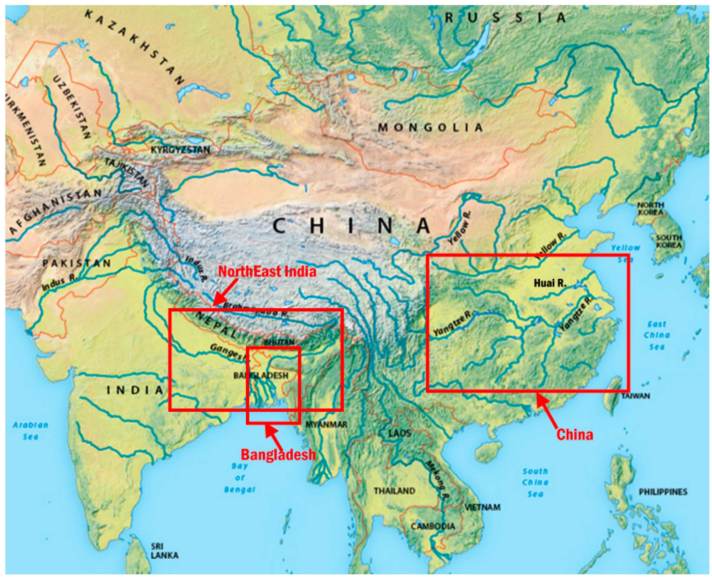
1. Introduction
2. Data and Methods
2.1. Data Used
- VIIRS SDR (Sensor Data Record) data at Imager bands 1, 2, 3 and 5 with 375-m spatial resolution.
- Geolocation data, including longitude, latitude, solar zenith angles, solar azimuth angles, sensor zenith angles and sensor azimuth angles.
- VIIRS Intermediate Cloud Mask Product with 750-m resolution.
- Static ancillary datasets include:
- The population count dataset for China, Bangladesh, and India in 2020 at a resolution of 3 arc-seconds (approximately 100 m at the equator) is obtained from the WorldPop [40]. This database has been continuously updated every year.
2.2. Methods
2.2.1. VIIRS Flood Detection
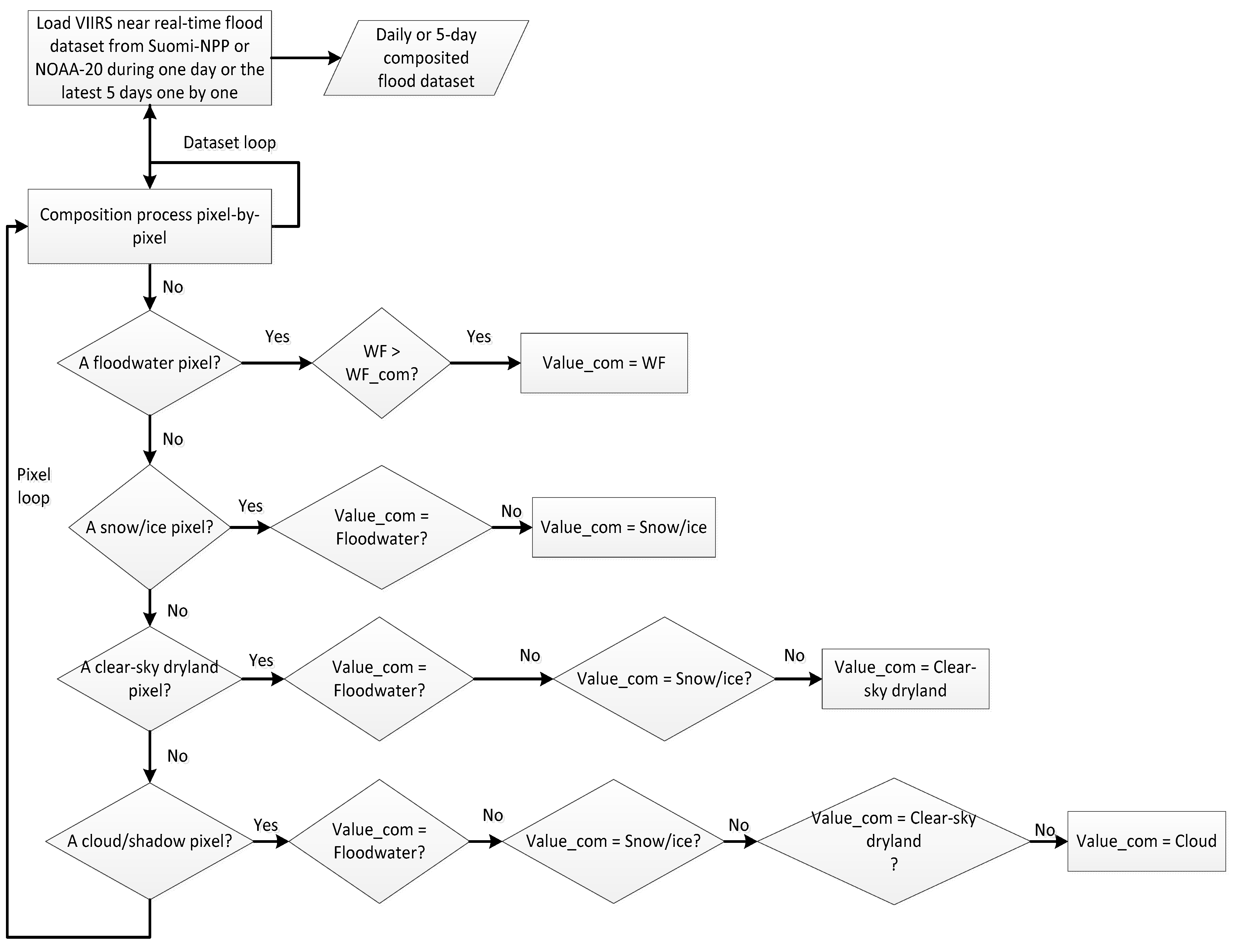
2.2.2. Multiple-Day Composition
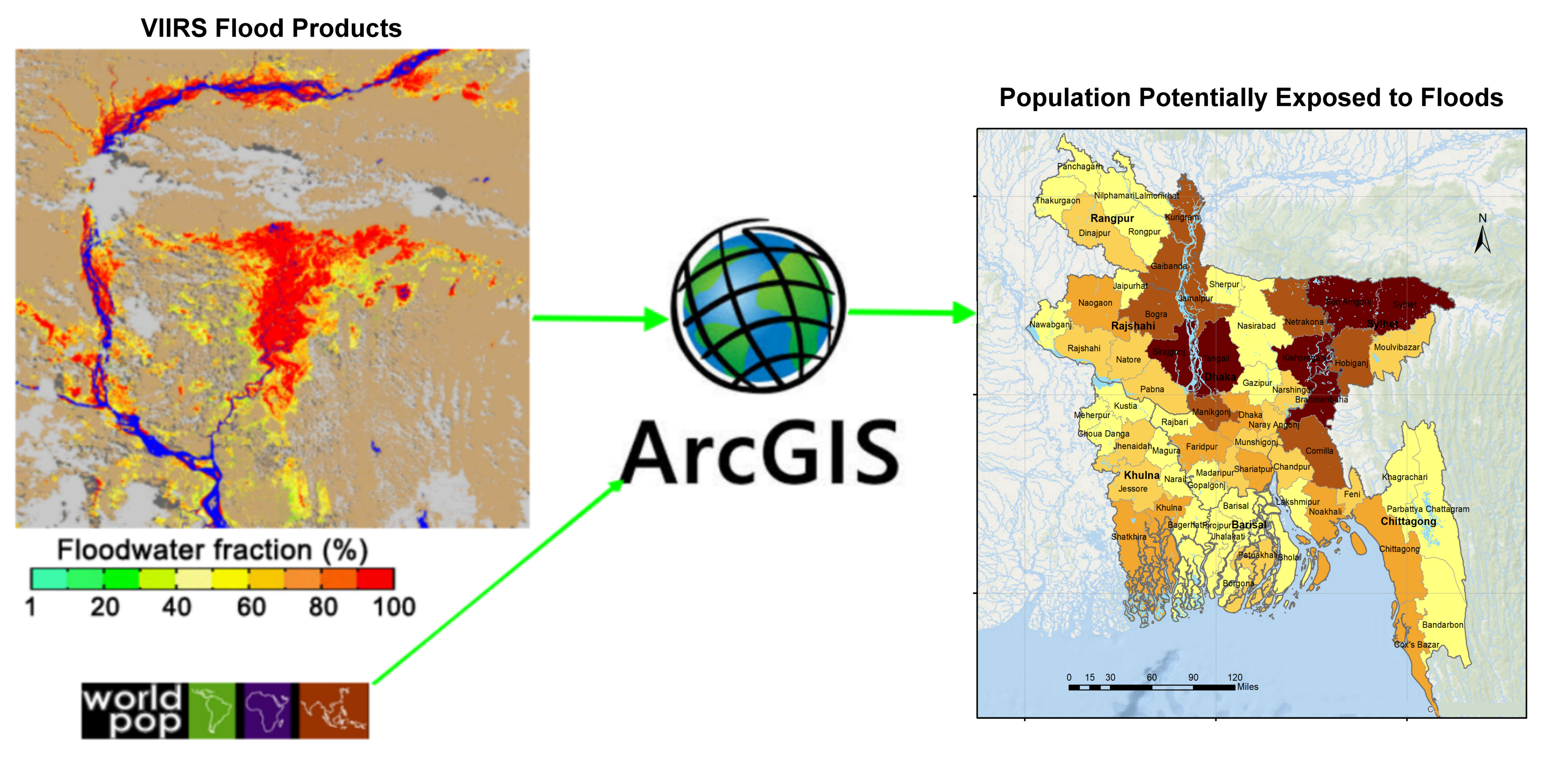
2.2.3. Spatial Analysis
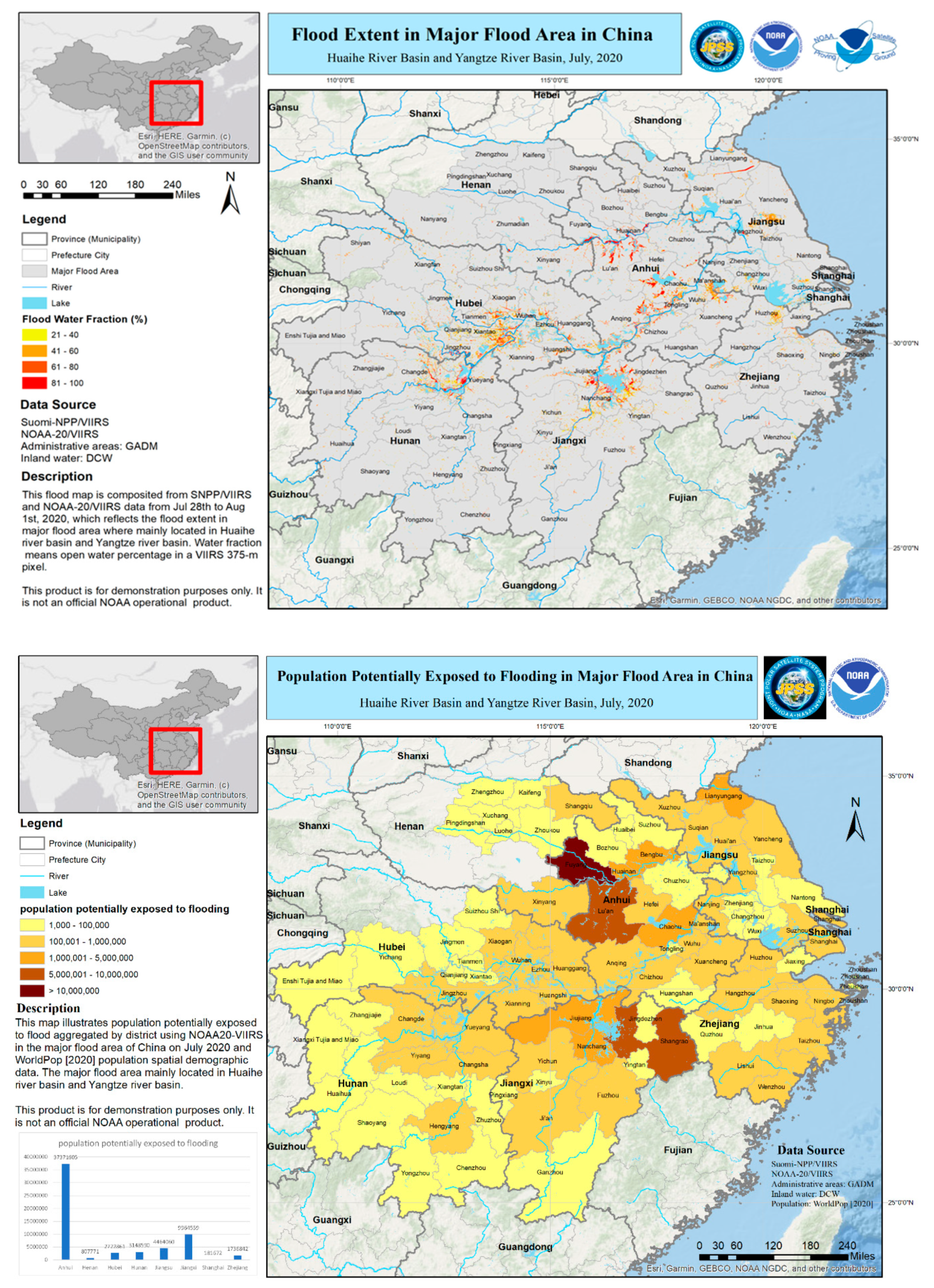
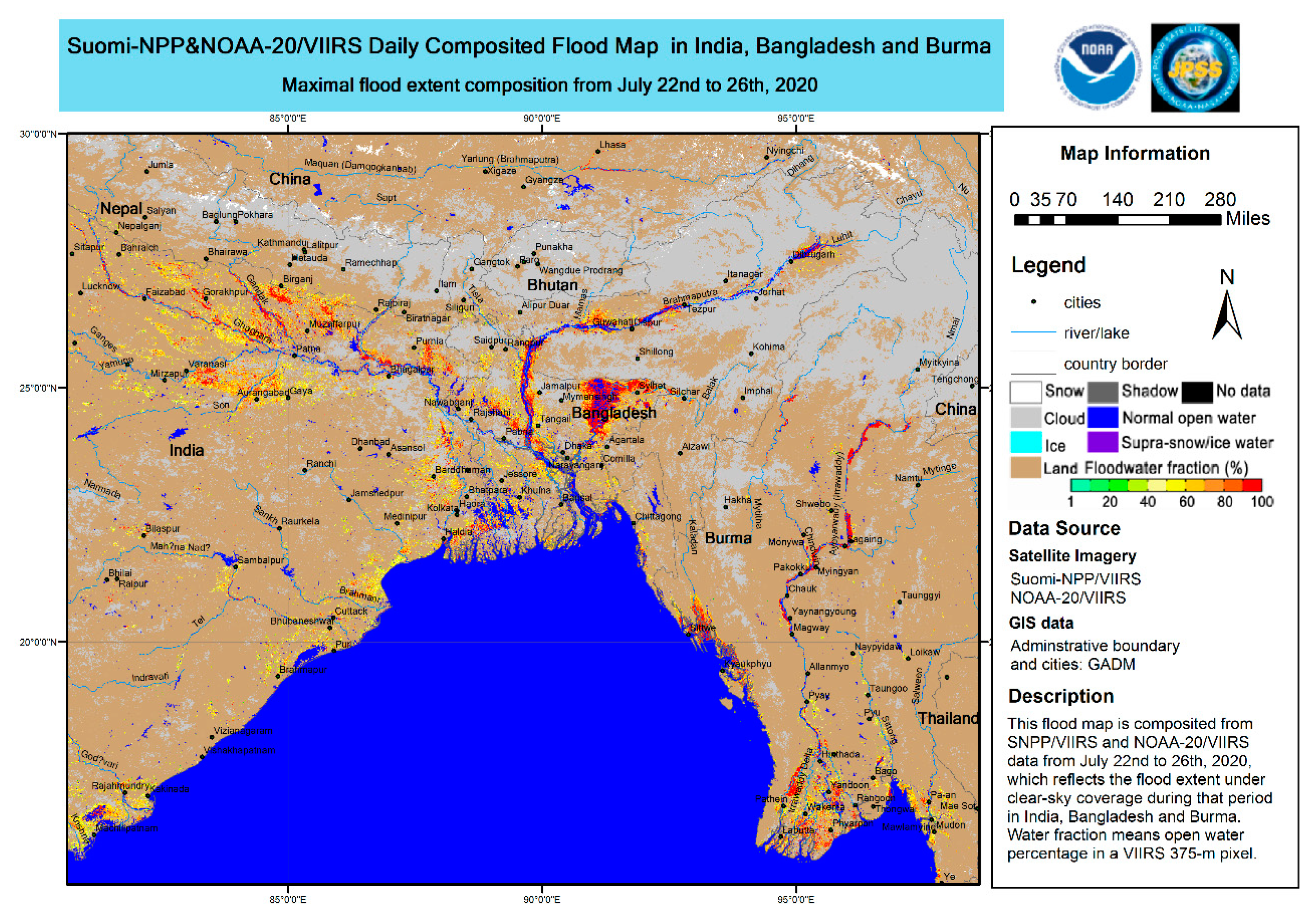
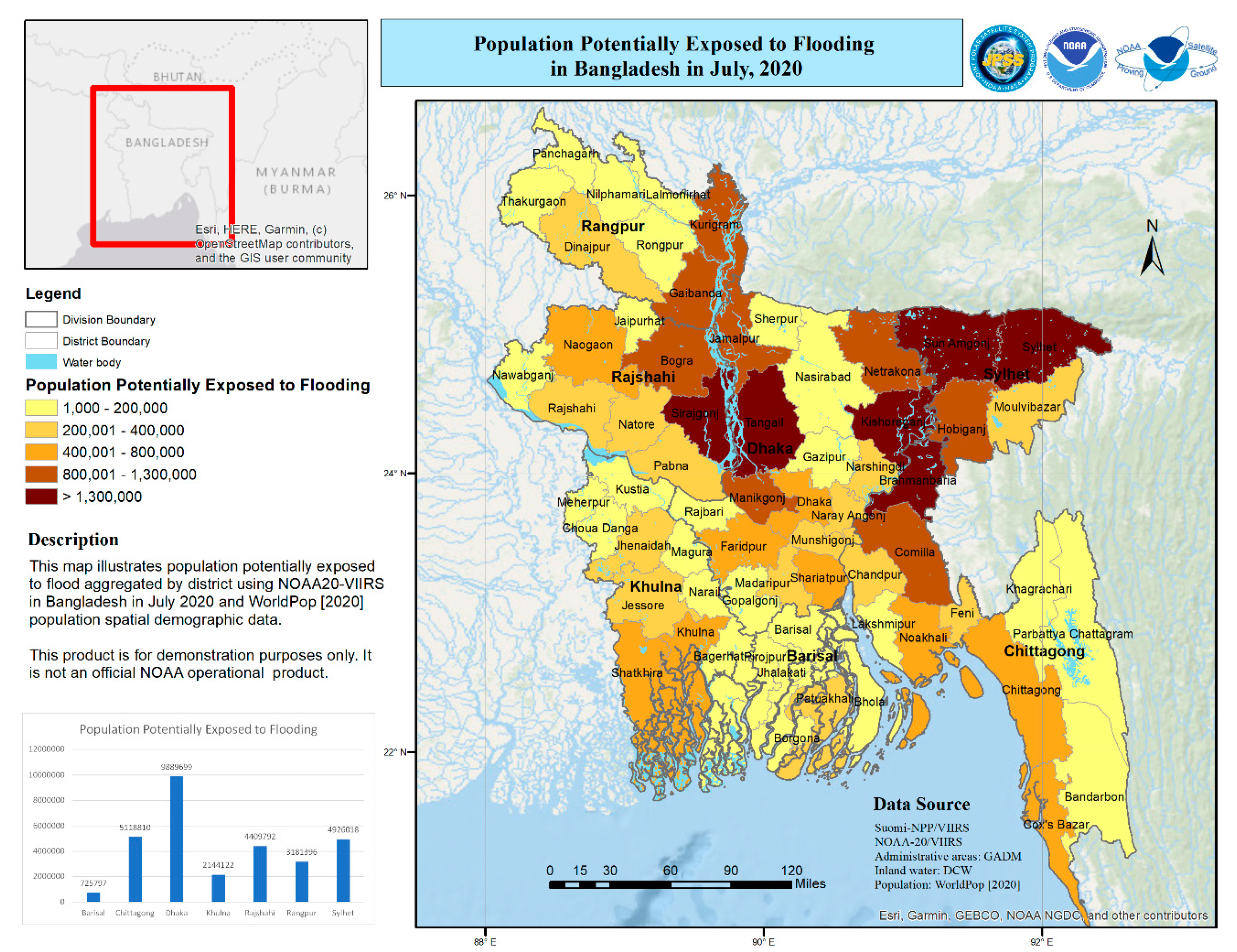
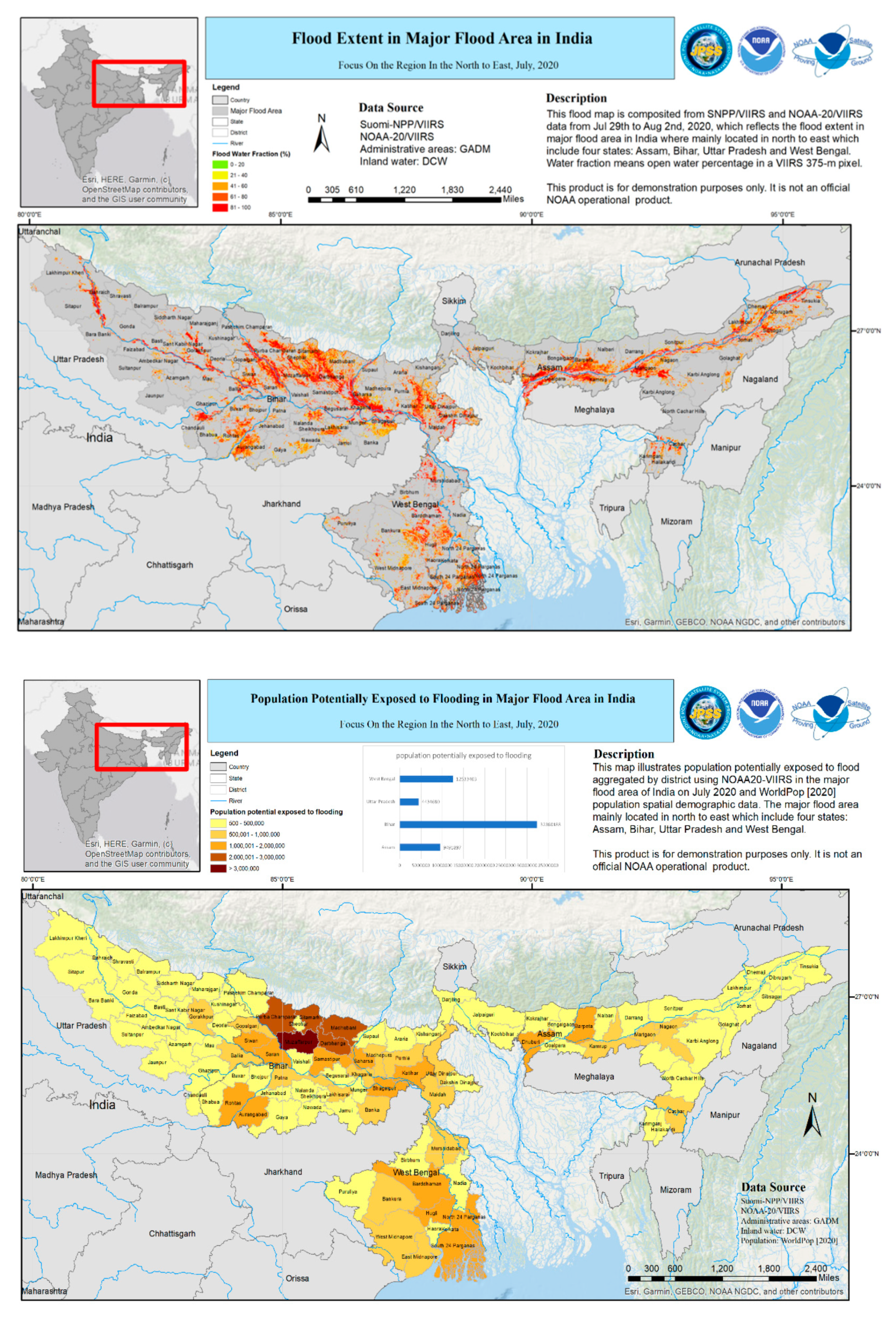
3. Results
4. Discussion
5. Conclusions
Author Contributions
Funding
Acknowledgments
Conflicts of Interest
References
- Kundzewicz, Z.W.; Schellnhuber, H.J. Floods in the IPCC TAR perspective. Nat. Hazards 2004, 31, 111–128. [Google Scholar] [CrossRef]
- International Federation of the Red Cross and Red Crescent Societies (IFRC). World Disasters Report; Oxford University Press: Oxford, UK, 2008; ISBN 978-92-9139-156-1. [Google Scholar]
- Clift, P.D.; Holbourn, A.; France-Lanord, C.; Zheng, H. Evolution of the Asian Monsoon; Eos: Washington, DC, USA, 2020; p. 101. [Google Scholar] [CrossRef]
- Yu, Z. Floods in China: Can the Three Gorges Dam weather once-in-a-century massive floods in the Yangtze River? Think China, 11 July 2020. [Google Scholar]
- Lew, L. After coronavirus, Flooding Hits Southern China with 14 Million Affected. South China Morning Post, 29 June 2020. [Google Scholar]
- More Chinese Regions Brace for Floods as Storms Shift East. Reuters, 29 June 2020.
- Yan, L. Emergency Management Division: Floods caused 5481.1 affected people in 27 provinces in China. China News, 28 July 2020. (In Chinese) [Google Scholar]
- ReliefWeb. Bangladesh: Floods and Landslides—July 2020. Available online: https://reliefweb.int/disaster/fl-2020-000161-bgd (accessed on 15 August 2020).
- ReliefWeb. India: Floods and Landslides—July 2020. Available online: https://reliefweb.int/disaster/fl-2020-000164-ind (accessed on 15 August 2020).
- Rodriguez, J.; Vos, F.; Below, R.; Guha-Sapir, D. Annual Disaster Statistical Review 2008: The Numbers and Trends; CRED: Brussels, Belgium, 2008. [Google Scholar]
- Christoplos, I.; Mitchell, J.; Liljelund, A. Re-framing risk: The changing context of disaster mitigation and preparedness. Disasters 2001, 25, 185–198. [Google Scholar] [CrossRef] [PubMed]
- Schumann, G.J.; Domeneghetti, A. Exploiting the proliferation of current and future satellite observations of rivers. Hydrol. Process. 2016, 30, 2891–2896. [Google Scholar] [CrossRef]
- Barton, I.J.; Bathols, J.M. Monitoring floods with AVHRR. Remote Sens. Environ. 1989, 30, 89–94. [Google Scholar] [CrossRef]
- Ali, A. Study of river flood hydrology in Bangladesh with AVHRR data. Int. J. Remote Sens. 1989, 10, 1873–1892. [Google Scholar] [CrossRef]
- Sheng, Y.; Xiao, Q. Water Identification in Cloud-contaminated NOAA/AVHRR Imagery. Remote Sens. Environ. China 1994, 9, 247–255. [Google Scholar]
- Sheng, Y.; Su, Y.; Xiao, Q. Challenging the cloud-contamination problem in flood monitoring with NOAA/AVHRR imagery. Photogramm. Eng. Remote Sens. 1998, 64, 191–198. [Google Scholar]
- Sheng, Y.; Gong, P. Quantitative dynamic flood monitoring with NOAA AVHRR. Int. J. Remote Sens. 2001, 22, 1709–1724. [Google Scholar] [CrossRef]
- Carroll, M.; Townshend, J.; DiMiceli, C.; Noojipady, P.; Sohlberg, R. A New Global Raster Water Mask at 250 Meter Resolution. Int. J. Digit. Earth 2009, 2, 291–308. [Google Scholar] [CrossRef]
- Sun, D.L.; Yu, Y.; Goldberg, M.D. Deriving water fraction and flood maps from MODIS images using a decision tree approach. IEEE J. Sel. Top. Appl. Earth Obs. Remote Sens. 2011, 4, 814–825. [Google Scholar] [CrossRef]
- Sun, D.L.; Yu, Y.; Zhang, R.; Li, S.; Goldberg, M.D. Towards Operational Automatic Flood Detection Using EOS/MODIS data. Photogramm. Eng. Remote Sens. 2012, 78, 637–646. [Google Scholar] [CrossRef]
- Li, S.; Sun, D.; Yu, Y.; Csiszar, I.; Stefanidis, A.; Goldberg, M.D. A New Shortwave Infrared (SWIR) Method for Quantitative Water Fraction Derivation and Evaluation with EOS/MODIS and Landsat/TM data. IEEE Trans. Geosci. Remote Sens. 2012, 51, 1852–1862. [Google Scholar] [CrossRef]
- Li, S.; Sun, D.; Goldberg, M.D.; Stefanidis, A. Derivation of 30-m-resolution Water Maps from TERRA/MODIS and SRTM. Remote Sens. Environ. 2013, 134, 417–430. [Google Scholar] [CrossRef]
- Schumann, G.; Wells, G.; Adler, R.; Brakenridge, R.; Bolten, J.; Murray, J.; Slayback, D.; Policelli, F.; Kirschbaum, D.; Wu, H.; et al. Unlocking the full potential of Earth observation during the 2015 Texas flood disaster. Water Resour. Res. 2016, 52, 3288–3293. [Google Scholar] [CrossRef]
- Schumann, G.J.-P. Flood response using Earth observation data and products. EOS 2016, 97. [Google Scholar] [CrossRef]
- Schumann, G.J.-P. Preface: Remote sensing in flood monitoring and management. Remote Sens. 2015, 7, 17013–17015. [Google Scholar] [CrossRef] [Green Version]
- Martinis, S.; Twele, A.; Strobl, C.; Kersten, J.; Stein, E. A multi-scale flood monitoring system based on fully automatic MODIS and TerraSAR-X processing chains. Remote Sens. 2013, 5, 5598–5619. [Google Scholar] [CrossRef] [Green Version]
- Cao, C.; De Luccia, F.J.; Xiong, X.; Wolfe, R.; Weng, F. Early On-Orbit Performance of the Visible Infrared Imaging Radiometer Suite Onboard the Suomi National Polar-Orbiting Partnership (S-NPP) Satellite. IEEE Trans. Geosci. Remote Sens. 2014, 52, 1142–1156. [Google Scholar] [CrossRef] [Green Version]
- Li, S.; Sun, D.; Yu, Y. Automatic cloud-shadow removal from flood/standing water maps using MSG/SEVIRI imagery. Int. J. Remote Sens. 2013, 34, 5487–5502. [Google Scholar] [CrossRef]
- Li, S.; Sun, D.; Goldberg, M.D.; Sjoberg, W. Object-based automatic terrain shadow removal from SNPP/VIIRS flood maps. Int. J. Remote Sens. 2015, 36, 5504–5522. [Google Scholar] [CrossRef]
- Li, S.; Sun, D.; Goldberg, M.D.; Sjoberg, W.; Santek, D.; Hoffman, J.P.; DeWeese, M.; Restrepo, P.; Lindsey, S.; Holloway, E. Automatic near real-time flood detection using Suomi-NPP/VIIRS data. Remote Sens. Environ. 2017, 204, 672–689. [Google Scholar] [CrossRef]
- Temimi, M.; Leconte, R.; Brissette, F.; Chaouch, N. Flood and soil wetness monitoring over the Mackenzie River Basin using AMSR-E 37 GHz brightness temperature. J. Hydrol. 2007, 333, 317–328. [Google Scholar] [CrossRef]
- Zheng, W.; Liu, C.; Wang, Z.X.; Xin, Z.B. Flood and waterlogging monitoring over Huaihe River Basin by AMSR-E data analysis. Chin. Geogr. Sci. 2008, 18, 262–267. [Google Scholar] [CrossRef] [Green Version]
- Sun, D.; Li, S.; Zheng, W.; Croitoru, A.; Stefanidis, A.; Goldberg, M.D. Mapping floods due to Hurricane Sandy using NPP VIIRS and ATMS data and geotagged Flickr imagery. Int. J. Dig. Earth 2015, 6. [Google Scholar] [CrossRef]
- Zheng, W.; Sun, D.; Li, S. Mapping Coastal Floods Induced by Hurricane Storm Surge using ATMS Data. Int. J. Remote Sens. 2017, 38, 6846–6864. [Google Scholar] [CrossRef]
- Bates, P.D.; Wilson, M.D.; Horritt, M.S.; Mason, D.C.; Holden, N.; Currie, A. Reach scale floodplain inundation dynamics observed using airborne synthetic aperture radar imagery: Data analysis and modelling. J. Hydrol. 2006, 328, 306–318. [Google Scholar] [CrossRef]
- Goldberg, M.; Li, S.; Goodman, S.; Lindsey, D.; Sjoberg, B.; Sun, D. Contributions of Operational Satellites in Monitoring the Catastrophic Floodwaters Due to Hurricane Harvey. Remote Sens. 2018, 10, 1256. [Google Scholar] [CrossRef] [Green Version]
- Goldberg, M.; Li, S.; Lindsey, D.; Sjoberg, B.; Zhou, L.; Sun, D. Mapping, Monitoring, and Prediction of Floods Due to Ice Jam and Snowmelt with Operational Weather Satellites. Remote Sens. 2020, 12, 1865. [Google Scholar] [CrossRef]
- Guha-Sapir, D.; Rodriguez-Llanes, J.M.; Jakubicka, T. Using disaster footprints, population databases and GIS to overcome persistent problems for human impact assessment in flood events. Nat. Hazards 2011, 58, 845–852. [Google Scholar] [CrossRef] [Green Version]
- Xian, G.; Homer, C.; Dewitz, J.; Fry, J.; Hossain, N.; Wickham, J. The change of impervious surface area between 2001 and 2006 in the conterminous United States. Photogramm. Eng. Remote Sens. 2011, 77, 758–762. [Google Scholar]
- Tatem, A.J. WorldPop, open data for spatial demography. Sci. Data 2017, 4, 170004. [Google Scholar] [CrossRef] [PubMed]
- Clark, M.J. Putting water in its place: A perspective on GIS in hydrology and water management. Hydrol. Process. 1998, 12, 823–834. [Google Scholar] [CrossRef]
- Zerger, A.; Wealands, S. Beyond modelling: Linking models with GIS for flood risk management. Nat. Hazards 2004, 33, 191–208. [Google Scholar] [CrossRef]
- Peduzzi, P.; Dao, H.; Herold, C.; Mouton, F. Assessing global exposure and vulnerability towards natural hazards: The disaster risk index. Nat. Hazards Earth Syst. Sci. 2009, 9, 1149–1159. [Google Scholar] [CrossRef]
- The VIIRS Flood Products at the SSEC’s Real Earth. Available online: https://www.ssec.wisc.edu/flood-map-demo/flood-products/ (accessed on 24 August 2020).
- JPSS Proving Ground Global Flood Products Archive. Available online: https://jpssflood.gmu.edu/ (accessed on 24 August 2020).


© 2020 by the authors. Licensee MDPI, Basel, Switzerland. This article is an open access article distributed under the terms and conditions of the Creative Commons Attribution (CC BY) license (http://creativecommons.org/licenses/by/4.0/).
Share and Cite
Li, S.; Goldberg, M.D.; Sjoberg, W.; Zhou, L.; Nandi, S.; Chowdhury, N.; Straka, W., III; Yang, T.; Sun, D. Assessment of the Catastrophic Asia Floods and Potentially Affected Population in Summer 2020 Using VIIRS Flood Products. Remote Sens. 2020, 12, 3176. https://doi.org/10.3390/rs12193176
Li S, Goldberg MD, Sjoberg W, Zhou L, Nandi S, Chowdhury N, Straka W III, Yang T, Sun D. Assessment of the Catastrophic Asia Floods and Potentially Affected Population in Summer 2020 Using VIIRS Flood Products. Remote Sensing. 2020; 12(19):3176. https://doi.org/10.3390/rs12193176
Chicago/Turabian StyleLi, Sanmei, Mitchell D. Goldberg, William Sjoberg, Lihang Zhou, Sreela Nandi, Nazmi Chowdhury, William Straka, III, Tianshu Yang, and Donglian Sun. 2020. "Assessment of the Catastrophic Asia Floods and Potentially Affected Population in Summer 2020 Using VIIRS Flood Products" Remote Sensing 12, no. 19: 3176. https://doi.org/10.3390/rs12193176